Oko Ita geodata
Oko Ita (Akwa Ibom) is a seat of a second-order administrative division; located in Nigeria in Africa/Lagos (GMT+1) time zone. In our database, there are 451 cities with bigger population. Compared to other cities in Nigeria, 92.2% of cities are located further ↑North; 61.5% of cities are located further ←West and 83.2% of cities have higher elevation than Oko Ita. Note1


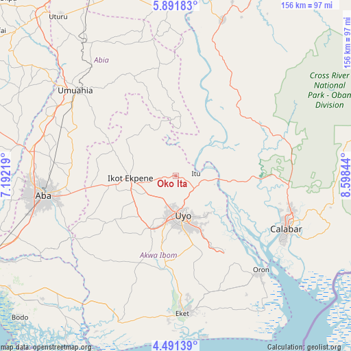
Oko Ita GPS coordinates[2]
5° 11' 31.2" North, 7° 53' 43.116" East
| Map corner | latitude | longitude |
|---|---|---|
| Upper-left | 5.89183°, | 7.19219° |
| Center: | 5.192°, | 7.89531° |
| Lower-right: | 4.49139°, | 8.59844° |
| Map W x H: | 155.7×155.7 km | = 96.7×96.7mi |
| max Lat: | 13.7543° ⇑92.2% North |
| Oko Ita: | 5.192° |
| min Lat: | ⇓7.8% South 4.31231° |
| min Long | Oko Ita | max Long |
| 2.73333° | 7.89531° | 14.46552° |
| W 61.5%⇐ | ⇒38.5% E |
Elevation
Elevation of Oko Ita is 66 m = 217 ft, and this is 230.5 m = 756 ft below average elevation for this country.
| Max E: |
1599 m = 5246 ft | 83.2% |
| Avg. | 296.5 m = 973 ft | |
| Oko Ita | 66 m = 217 ft | |
Min E: |
2 m = 7 ft | 16.8% |
See also: Nigeria elevation on elevation.city.
Geographical zone
Oko Ita is located in North Torrid zone (between Equator and Tropic of Cancer). Distance of Equator is 577.3 km =358.7 mi to South.| Distance of | km | miles | from Oko Ita |
|---|---|---|---|
| North Pole | 9429.8 | 5859.4 | to North |
| Arctic Circle | 6823.9 | 4240.2 | to North |
| Tropic Cancer | 2028.6 | 1260.5 | to North |
| Equator | 577.3 | 358.7 | to South |


Nearby cities:
15 places around Oko Ita: (largest is in red/bold)
• Abak
26.1 km =16.2 mi,  206°
206°
• Afaha Ikot Ebak
27.4 km =17 mi,  254°
254°
• Afaha Offiong
36.7 km =22.8 mi,  178°
178°
• Akankpa
33.4 km =20.8 mi,  102°
102°
• Arochukwu
22 km =13.7 mi,  4°
4°
• Etinan
39.1 km =24.3 mi,  186°
186°
• Ibiaku Ntok Okpo
24.2 km =15 mi,  302°
302°
• Idu
22.5 km =14 mi,  143°
143°
• Ikot Ekpene
20 km =12.4 mi,  266°
266°
• Itu
9.8 km =6.1 mi,  83°
83°
• Nto Edino
36.1 km =22.4 mi,  281°
281°
• Nung Udoe
31.5 km =19.6 mi,  166°
166°
• Odoro Ikpe
24.4 km =15.2 mi,  319°
319°
• Utu Etim Ekpo
37.8 km =23.5 mi,  236°
236°
• Uyo
16.2 km =10.1 mi,  164°
164°
Sources, notices
• [Note1] Compared only with cities in Nigeria existing in our database
• [Src1] Map data: © OpenStreetMap contributors (CC-BY-SA)
• [Src2] Other city data from geonames.org with taken over terms of usage.
• [Src3] Geographical zone / Annual Mean Temperature by Robert A. Rohde @ Wikipedia
