Ogurugu geodata
Ogurugu (Kogi) is a populated place; located in Nigeria in Africa/Lagos (GMT+1) time zone. With population of 9,135 people, there are 354 cities with bigger population in this country. Compared to other cities in Nigeria, 71.2% of cities are located further ↑North; 57.7% of cities are located further →East and 85.5% of cities have higher elevation than Ogurugu. Note1


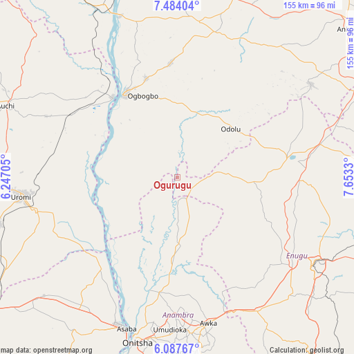
Ogurugu GPS coordinates[2]
6° 47' 10.896" North, 6° 57' 0.612" East
| Map corner | latitude | longitude |
|---|---|---|
| Upper-left | 7.48404°, | 6.24705° |
| Center: | 6.78636°, | 6.95017° |
| Lower-right: | 6.08767°, | 7.6533° |
| Map W x H: | 155.3×155.3 km | = 96.5×96.5mi |
| max Lat: | 13.7543° ⇑71.2% North |
| Ogurugu: | 6.78636° |
| min Lat: | ⇓28.8% South 4.31231° |
| min Long | Ogurugu | max Long |
| 2.73333° | 6.95017° | 14.46552° |
| W 42.3%⇐ | ⇒57.7% E |
Elevation
Elevation of Ogurugu is 54 m = 177 ft, and this is 242.5 m = 796 ft below average elevation for this country.
| Max E: |
1599 m = 5246 ft | 85.5% |
| Avg. | 296.5 m = 973 ft | |
| Ogurugu | 54 m = 177 ft | |
Min E: |
2 m = 7 ft | 14.5% |
See also: Nigeria elevation on elevation.city.
Geographical zone
Ogurugu is located in North Torrid zone (between Equator and Tropic of Cancer). Distance of Equator is 754.6 km =468.9 mi to South.| Distance of | km | miles | from Ogurugu |
|---|---|---|---|
| North Pole | 9252.5 | 5749.2 | to North |
| Arctic Circle | 6646.6 | 4130 | to North |
| Tropic Cancer | 1851.3 | 1150.3 | to North |
| Equator | 754.6 | 468.9 | to South |


Nearby cities:
15 places around Ogurugu: (largest is in red/bold)
• Achalla
50.4 km =31.3 mi,  175°
175°
• Adani
8.5 km =5.3 mi,  127°
127°
• Adoru
31.6 km =19.6 mi,  47°
47°
• Agenebode
45.4 km =28.2 mi,  321°
321°
• Ajaka
45.3 km =28.1 mi,  342°
342°
• Aku
41.5 km =25.8 mi,  101°
101°
• Anaku
35.4 km =22 mi, 183°
• Idah
43.2 km =26.8 mi,  327°
327°
• Illushi
37.7 km =23.4 mi,  250°
250°
• Nsukka
49.8 km =30.9 mi,  80°
80°
• Nzam
44.4 km =27.6 mi,  213°
213°
• Ogbede
48.5 km =30.1 mi,  105°
105°
• Onyedega
32.1 km =19.9 mi,  289°
289°
• Ugwolawo
50.2 km =31.2 mi,  356°
356°
• Umulona
35 km =21.7 mi,  152°
152°
Sources, notices
• [Note1] Compared only with cities in Nigeria existing in our database
• [Src1] Map data: © OpenStreetMap contributors (CC-BY-SA)
• [Src2] Other city data from geonames.org with taken over terms of usage.
• [Src3] Geographical zone / Annual Mean Temperature by Robert A. Rohde @ Wikipedia
