Talata Mafara geodata
Talata Mafara (Zamfara) is a seat of a second-order administrative division; located in Nigeria in Africa/Lagos (GMT+1) time zone. With population of 39,045 people, there are 153 cities with bigger population in this country. Compared to other cities in Nigeria, 91.7% of cities are located further ↓South; 69.9% of cities are located further →East and 55.7% of cities have lower elevation than Talata Mafara. Note1


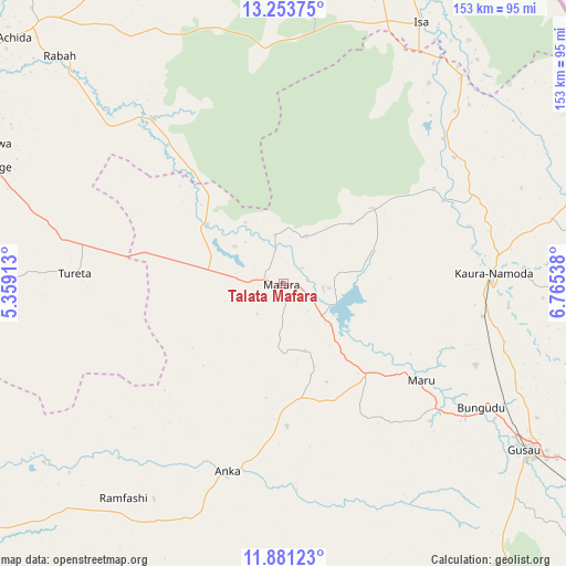
Talata Mafara GPS coordinates[2]
12° 34' 6.276" North, 6° 3' 44.1" East
| Map corner | latitude | longitude |
|---|---|---|
| Upper-left | 13.25375°, | 5.35913° |
| Center: | 12.56841°, | 6.06225° |
| Lower-right: | 11.88123°, | 6.76538° |
| Map W x H: | 152.6×152.6 km | = 94.8×94.8mi |
| max Lat: | 13.7543° ⇑8.3% North |
| Talata Mafara: | 12.56841° |
| min Lat: | ⇓91.7% South 4.31231° |
| min Long | Talata Mafara | max Long |
| 2.73333° | 6.06225° | 14.46552° |
| W 30.1%⇐ | ⇒69.9% E |
Elevation
Elevation of Talata Mafara is 316 m = 1037 ft, and this is 19.5 m = 64 ft above average elevation for this country.
| Max E: |
1599 m = 5246 ft | 44.3% |
| Talata Mafara | 316 m 1037 ft | |
| Avg. | 296.5 m = 973 ft | |
Min E: |
2 m = 7 ft | 55.7% |
See also: Nigeria elevation on elevation.city.
Geographical zone
Talata Mafara is located in North Torrid zone (between Equator and Tropic of Cancer). Distance of this Northern Tropic circle is 1208.4 km =750.9 mi to North.| Distance of | km | miles | from Talata Mafara |
|---|---|---|---|
| North Pole | 8609.6 | 5349.8 | to North |
| Arctic Circle | 6003.7 | 3730.5 | to North |
| Tropic Cancer | 1208.4 | 750.9 | to North |
| Equator | 1397.5 | 868.4 | to South |


Nearby cities:
15 places around Talata Mafara: (largest is in red/bold)
• Anka
52.7 km =32.7 mi,  196°
196°
• Bakura
25.9 km =16.1 mi,  307°
307°
• Bukkuyum
80.4 km =50 mi,  233°
233°
• Bungudu
62.9 km =39.1 mi,  122°
122°
• Dange
83.9 km =52.1 mi,  292°
292°
• Gandi
55.9 km =34.7 mi,  321°
321°
• Gusau
78.9 km =49 mi, 124°
• Isa
79.5 km =49.4 mi,  27°
27°
• Kaura Namoda
57 km =35.4 mi,  87°
87°
• Maradun
19.7 km =12.2 mi, 90°
• Maru
45.3 km =28.1 mi,  125°
125°
• Moriki
57.3 km =35.6 mi,  53°
53°
• Shinkafi
73.9 km =45.9 mi,  40°
40°
• Tureta
56.3 km =35 mi,  272°
272°
• Zurmi
81.7 km =50.8 mi,  73°
73°
Sources, notices
• [Note1] Compared only with cities in Nigeria existing in our database
• [Src1] Map data: © OpenStreetMap contributors (CC-BY-SA)
• [Src2] Other city data from geonames.org with taken over terms of usage.
• [Src3] Geographical zone / Annual Mean Temperature by Robert A. Rohde @ Wikipedia
