Kaura Namoda geodata
Kaura Namoda (Zamfara) is a seat of a second-order administrative division; located in Nigeria in Africa/Lagos (GMT+1) time zone. With population of 69,725 people, there are 135 cities with bigger population in this country. Compared to other cities in Nigeria, 91.9% of cities are located further ↓South; 63.5% of cities are located further →East and 69.5% of cities have lower elevation than Kaura Namoda. Note1


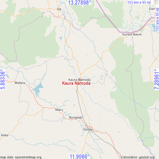
Kaura Namoda GPS coordinates[2]
12° 35' 37.356" North, 6° 35' 11.328" East
| Map corner | latitude | longitude |
|---|---|---|
| Upper-left | 13.27898°, | 5.88336° |
| Center: | 12.59371°, | 6.58648° |
| Lower-right: | 11.9066°, | 7.28961° |
| Map W x H: | 152.6×152.6 km | = 94.8×94.8mi |
| max Lat: | 13.7543° ⇑8.1% North |
| Kaura Namoda: | 12.59371° |
| min Lat: | ⇓91.9% South 4.31231° |
| min Long | Kaura Namoda | max Long |
| 2.73333° | 6.58648° | 14.46552° |
| W 36.5%⇐ | ⇒63.5% E |
Elevation
Elevation of Kaura Namoda is 396 m = 1299 ft, and this is 99.5 m = 326 ft above average elevation for this country.
| Max E: |
1599 m = 5246 ft | 30.5% |
| Kaura Namoda | 396 m 1299 ft | |
| Avg. | 296.5 m = 973 ft | |
Min E: |
2 m = 7 ft | 69.5% |
See also: Kaura Namoda elevation on elevation.city.
Geographical zone
Kaura Namoda is located in North Torrid zone (between Equator and Tropic of Cancer). Distance of this Northern Tropic circle is 1205.6 km =749.1 mi to North.| Distance of | km | miles | from Kaura Namoda |
|---|---|---|---|
| North Pole | 8606.8 | 5348 | to North |
| Arctic Circle | 6000.9 | 3728.8 | to North |
| Tropic Cancer | 1205.6 | 749.1 | to North |
| Equator | 1400.3 | 870.1 | to South |


Nearby cities:
15 places around Kaura Namoda: (largest is in red/bold)
• Bakura
78.4 km =48.7 mi,  279°
279°
• Batsari
74 km =46 mi,  75°
75°
• Birnin Magaji
33.7 km =20.9 mi,  96°
96°
• Bungudu
36.3 km =22.6 mi,  185°
185°
• Gusau
47.8 km =29.7 mi,  169°
169°
• Isa
70.3 km =43.7 mi,  343°
343°
• Kwatarkwashi
56.5 km =35.1 mi,  153°
153°
• Maradun
37.3 km =23.2 mi,  265°
265°
• Maru
35.1 km =21.8 mi,  214°
214°
• Moriki
33 km =20.5 mi, 341°
• Ruma
76.4 km =47.5 mi,  66°
66°
• Shinkafi
54 km =33.6 mi,  350°
350°
• Talata Mafara
57 km =35.4 mi, 267°
• Wagini
66.9 km =41.6 mi, 81°
• Zurmi
29.6 km =18.4 mi,  46°
46°
Sources, notices
• [Note1] Compared only with cities in Nigeria existing in our database
• [Src1] Map data: © OpenStreetMap contributors (CC-BY-SA)
• [Src2] Other city data from geonames.org with taken over terms of usage.
• [Src3] Geographical zone / Annual Mean Temperature by Robert A. Rohde @ Wikipedia
