Bakura geodata
Bakura (Zamfara) is a seat of a second-order administrative division; located in Nigeria in Africa/Lagos (GMT+1) time zone. In our database, there are 451 cities with bigger population. Compared to other cities in Nigeria, 93.7% of cities are located further ↓South; 71.8% of cities are located further →East and 51.6% of cities have lower elevation than Bakura. Note1


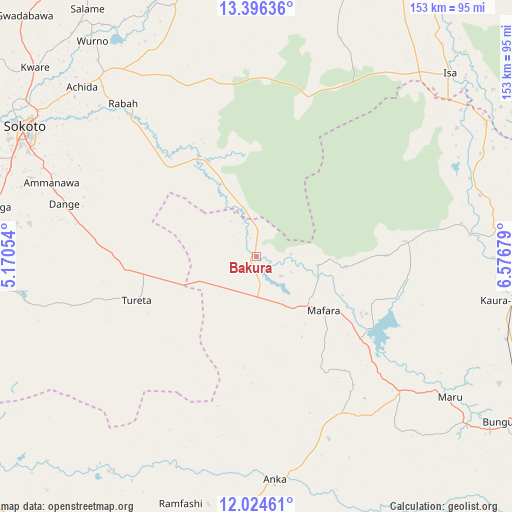
Bakura GPS coordinates[2]
12° 42' 41.076" North, 5° 52' 25.212" East
| Map corner | latitude | longitude |
|---|---|---|
| Upper-left | 13.39636°, | 5.17054° |
| Center: | 12.71141°, | 5.87367° |
| Lower-right: | 12.02461°, | 6.57679° |
| Map W x H: | 152.5×152.5 km | = 94.8×94.8mi |
| max Lat: | 13.7543° ⇑6.3% North |
| Bakura: | 12.71141° |
| min Lat: | ⇓93.7% South 4.31231° |
| min Long | Bakura | max Long |
| 2.73333° | 5.87367° | 14.46552° |
| W 28.2%⇐ | ⇒71.8% E |
Elevation
Elevation of Bakura is 293 m = 961 ft, and this is 3.5 m = 11 ft below average elevation for this country.
| Max E: |
1599 m = 5246 ft | 48.4% |
| Avg. | 296.5 m = 973 ft | |
| Bakura | 293 m = 961 ft | |
Min E: |
2 m = 7 ft | 51.6% |
See also: Nigeria elevation on elevation.city.
Geographical zone
Bakura is located in North Torrid zone (between Equator and Tropic of Cancer). Distance of this Northern Tropic circle is 1192.5 km =741 mi to North.| Distance of | km | miles | from Bakura |
|---|---|---|---|
| North Pole | 8593.7 | 5339.9 | to North |
| Arctic Circle | 5987.8 | 3720.6 | to North |
| Tropic Cancer | 1192.5 | 741 | to North |
| Equator | 1413.4 | 878.2 | to South |


Nearby cities:
15 places around Bakura: (largest is in red/bold)
• Anka
66.7 km =41.4 mi,  175°
175°
• Bodinga
79.8 km =49.6 mi,  280°
280°
• Bukkuyum
77.6 km =48.2 mi,  214°
214°
• Dange
59.4 km =36.9 mi,  285°
285°
• Gandi
31.4 km =19.5 mi,  333°
333°
• Isa
79.2 km =49.2 mi,  46°
46°
• Kaura Namoda
78.4 km =48.7 mi,  99°
99°
• Maradun
43.3 km =26.9 mi,  111°
111°
• Maru
71.2 km =44.2 mi,  126°
126°
• Moriki
69 km =42.9 mi,  74°
74°
• Rabah
60.5 km =37.6 mi,  319°
319°
• Shinkafi
79.4 km =49.3 mi,  59°
59°
• Sokoto
78.7 km =48.9 mi,  299°
299°
• Talata Mafara
25.9 km =16.1 mi, 127°
• Tureta
38.1 km =23.7 mi,  249°
249°
Sources, notices
• [Note1] Compared only with cities in Nigeria existing in our database
• [Src1] Map data: © OpenStreetMap contributors (CC-BY-SA)
• [Src2] Other city data from geonames.org with taken over terms of usage.
• [Src3] Geographical zone / Annual Mean Temperature by Robert A. Rohde @ Wikipedia
