Isa geodata
Isa (Sokoto) is a seat of a second-order administrative division; located in Nigeria in Africa/Lagos (GMT+1) time zone. In our database, there are 451 cities with bigger population. Compared to other cities in Nigeria, 98.7% of cities are located further ↓South; 65.6% of cities are located further →East and 56.6% of cities have lower elevation than Isa. Note1


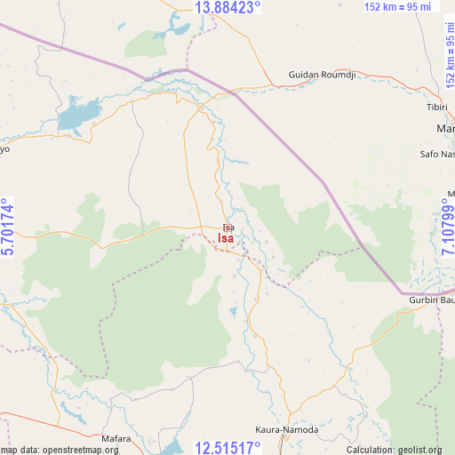
Isa GPS coordinates[2]
13° 12' 2.376" North, 6° 24' 17.532" East
| Map corner | latitude | longitude |
|---|---|---|
| Upper-left | 13.88423°, | 5.70174° |
| Center: | 13.20066°, | 6.40487° |
| Lower-right: | 12.51517°, | 7.10799° |
| Map W x H: | 152.2×152.2 km | = 94.6×94.6mi |
| max Lat: | 13.7543° ⇑1.3% North |
| Isa: | 13.20066° |
| min Lat: | ⇓98.7% South 4.31231° |
| min Long | Isa | max Long |
| 2.73333° | 6.40487° | 14.46552° |
| W 34.4%⇐ | ⇒65.6% E |
Elevation
Elevation of Isa is 322 m = 1056 ft, and this is 25.5 m = 84 ft above average elevation for this country.
| Max E: |
1599 m = 5246 ft | 43.4% |
| Isa | 322 m 1056 ft | |
| Avg. | 296.5 m = 973 ft | |
Min E: |
2 m = 7 ft | 56.6% |
See also: Nigeria elevation on elevation.city.
Geographical zone
Isa is located in North Torrid zone (between Equator and Tropic of Cancer). Distance of this Northern Tropic circle is 1138.1 km =707.2 mi to North.| Distance of | km | miles | from Isa |
|---|---|---|---|
| North Pole | 8539.3 | 5306.1 | to North |
| Arctic Circle | 5933.4 | 3686.8 | to North |
| Tropic Cancer | 1138.1 | 707.2 | to North |
| Equator | 1467.8 | 912 | to South |


Nearby cities:
15 places around Isa: (largest is in red/bold)
• Bakura
79.2 km =49.2 mi,  226°
226°
• Birnin Magaji
88.9 km =55.2 mi,  143°
143°
• Gandi
76.3 km =47.4 mi,  249°
249°
• Goronyo
83.7 km =52 mi,  288°
288°
• Jibia
89.7 km =55.7 mi,  97°
97°
• Kaura Namoda
70.3 km =43.7 mi,  163°
163°
• Maradun
72.6 km =45.1 mi,  193°
193°
• Maru
96.4 km =59.9 mi,  180°
180°
• Moriki
37.4 km =23.2 mi,  166°
166°
• Rabah
97.5 km =60.6 mi,  264°
264°
• Ruma
97.4 km =60.5 mi,  112°
112°
• Sabon Birni
41.3 km =25.7 mi,  347°
347°
• Shinkafi
17.9 km =11.1 mi, 142°
• Talata Mafara
79.5 km =49.4 mi,  207°
207°
• Zurmi
62.5 km =38.8 mi, 138°
Sources, notices
• [Note1] Compared only with cities in Nigeria existing in our database
• [Src1] Map data: © OpenStreetMap contributors (CC-BY-SA)
• [Src2] Other city data from geonames.org with taken over terms of usage.
• [Src3] Geographical zone / Annual Mean Temperature by Robert A. Rohde @ Wikipedia
