Moriki geodata
Moriki (Zamfara) is a populated place; located in Nigeria in Africa/Lagos (GMT+1) time zone. With population of 28,735 people, there are 165 cities with bigger population in this country. Compared to other cities in Nigeria, 95.8% of cities are located further ↓South; 64.8% of cities are located further →East and 61.2% of cities have lower elevation than Moriki. Note1


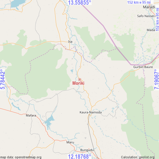
Moriki GPS coordinates[2]
12° 52' 26.58" North, 6° 29' 15.144" East
| Map corner | latitude | longitude |
|---|---|---|
| Upper-left | 13.55855°, | 5.78442° |
| Center: | 12.87405°, | 6.48754° |
| Lower-right: | 12.18768°, | 7.19067° |
| Map W x H: | 152.4×152.4 km | = 94.7×94.7mi |
| max Lat: | 13.7543° ⇑4.2% North |
| Moriki: | 12.87405° |
| min Lat: | ⇓95.8% South 4.31231° |
| min Long | Moriki | max Long |
| 2.73333° | 6.48754° | 14.46552° |
| W 35.2%⇐ | ⇒64.8% E |
Elevation
Elevation of Moriki is 353 m = 1158 ft, and this is 56.5 m = 185 ft above average elevation for this country.
| Max E: |
1599 m = 5246 ft | 38.8% |
| Moriki | 353 m 1158 ft | |
| Avg. | 296.5 m = 973 ft | |
Min E: |
2 m = 7 ft | 61.2% |
See also: Nigeria elevation on elevation.city.
Geographical zone
Moriki is located in North Torrid zone (between Equator and Tropic of Cancer). Distance of this Northern Tropic circle is 1174.5 km =729.8 mi to North.| Distance of | km | miles | from Moriki |
|---|---|---|---|
| North Pole | 8575.6 | 5328.6 | to North |
| Arctic Circle | 5969.7 | 3709.4 | to North |
| Tropic Cancer | 1174.5 | 729.8 | to North |
| Equator | 1431.5 | 889.5 | to South |


Nearby cities:
15 places around Moriki: (largest is in red/bold)
• Bakura
69 km =42.9 mi,  254°
254°
• Birnin Magaji
56.3 km =35 mi,  128°
128°
• Bungudu
67.7 km =42.1 mi,  173°
173°
• Gandi
81.3 km =50.5 mi,  277°
277°
• Gusau
80.6 km =50.1 mi, 166°
• Isa
37.4 km =23.2 mi,  346°
346°
• Kaura Namoda
33 km =20.5 mi,  161°
161°
• Maradun
43.2 km =26.8 mi,  217°
217°
• Maru
60.8 km =37.8 mi,  188°
188°
• Ruma
81 km =50.3 mi,  90°
90°
• Sabon Birni
78.7 km =48.9 mi, 346°
• Shinkafi
22.2 km =13.8 mi,  5°
5°
• Talata Mafara
57.3 km =35.6 mi,  233°
233°
• Wagini
79.5 km =49.4 mi,  105°
105°
• Zurmi
33.9 km =21.1 mi, 108°
Sources, notices
• [Note1] Compared only with cities in Nigeria existing in our database
• [Src1] Map data: © OpenStreetMap contributors (CC-BY-SA)
• [Src2] Other city data from geonames.org with taken over terms of usage.
• [Src3] Geographical zone / Annual Mean Temperature by Robert A. Rohde @ Wikipedia
