Paiko geodata
Paiko (Niger) is a seat of a second-order administrative division; located in Nigeria in Africa/Lagos (GMT+1) time zone. In our database, there are 451 cities with bigger population. Compared to other cities in Nigeria, 59% of cities are located further ↓South; 63.2% of cities are located further →East and 55.1% of cities have lower elevation than Paiko. Note1


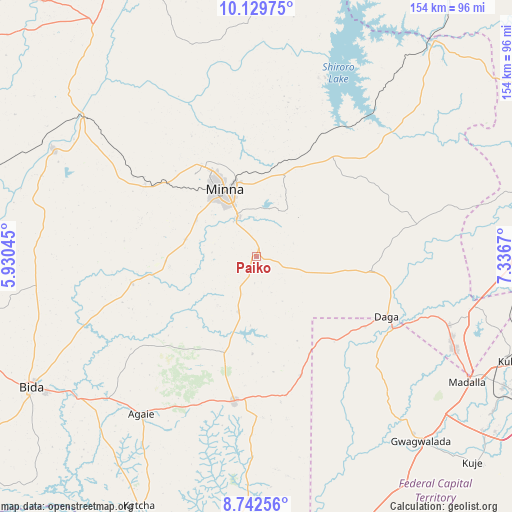
Paiko GPS coordinates[2]
9° 26' 12.66" North, 6° 38' 0.852" East
| Map corner | latitude | longitude |
|---|---|---|
| Upper-left | 10.12975°, | 5.93045° |
| Center: | 9.43685°, | 6.63357° |
| Lower-right: | 8.74256°, | 7.3367° |
| Map W x H: | 154.2×154.2 km | = 95.8×95.8mi |
| max Lat: | 13.7543° ⇑41% North |
| Paiko: | 9.43685° |
| min Lat: | ⇓59% South 4.31231° |
| min Long | Paiko | max Long |
| 2.73333° | 6.63357° | 14.46552° |
| W 36.8%⇐ | ⇒63.2% E |
Elevation
Elevation of Paiko is 312 m = 1024 ft, and this is 15.5 m = 51 ft above average elevation for this country.
| Max E: |
1599 m = 5246 ft | 44.9% |
| Paiko | 312 m 1024 ft | |
| Avg. | 296.5 m = 973 ft | |
Min E: |
2 m = 7 ft | 55.1% |
See also: Nigeria elevation on elevation.city.
Geographical zone
Paiko is located in North Torrid zone (between Equator and Tropic of Cancer). Distance of Equator is 1049.3 km =652 mi to South.| Distance of | km | miles | from Paiko |
|---|---|---|---|
| North Pole | 8957.8 | 5566.1 | to North |
| Arctic Circle | 6351.9 | 3946.9 | to North |
| Tropic Cancer | 1556.6 | 967.2 | to North |
| Equator | 1049.3 | 652 | to South |


Nearby cities:
15 places around Paiko: (largest is in red/bold)
• Agaie
58.9 km =36.6 mi,  216°
216°
• Badeggi
68.5 km =42.6 mi,  231°
231°
• Gawu Babangida
43.2 km =26.8 mi,  114°
114°
• Gwagwalada
73.7 km =45.8 mi,  138°
138°
• Kuta
48.7 km =30.3 mi,  9°
9°
• Kwali
74.6 km =46.4 mi,  145°
145°
• Lapai
44.2 km =27.5 mi,  188°
188°
• Lemu
66.6 km =41.4 mi,  266°
266°
• Madala
73.6 km =45.7 mi,  120°
120°
• Maikunkele
32.3 km =20.1 mi,  328°
328°
• Minna
22 km =13.7 mi, 334°
• Sabon Wuse
69.8 km =43.4 mi,  99°
99°
• Suleja
66.3 km =41.2 mi, 115°
• Wushishi
69.6 km =43.2 mi,  297°
297°
• Zungeru
66.9 km =41.6 mi,  307°
307°
Sources, notices
• [Note1] Compared only with cities in Nigeria existing in our database
• [Src1] Map data: © OpenStreetMap contributors (CC-BY-SA)
• [Src2] Other city data from geonames.org with taken over terms of usage.
• [Src3] Geographical zone / Annual Mean Temperature by Robert A. Rohde @ Wikipedia
