Lapai geodata
Lapai (Niger) is a seat of a second-order administrative division; located in Nigeria in Africa/Lagos (GMT+1) time zone. With population of 16,442 people, there are 224 cities with bigger population in this country. Compared to other cities in Nigeria, 55.2% of cities are located further ↓South; 63.6% of cities are located further →East and 66.4% of cities have higher elevation than Lapai. Note1


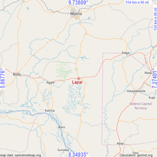
Lapai GPS coordinates[2]
9° 2' 39.804" North, 6° 34' 15.204" East
| Map corner | latitude | longitude |
|---|---|---|
| Upper-left | 9.73809°, | 5.86776° |
| Center: | 9.04439°, | 6.57089° |
| Lower-right: | 8.34935°, | 7.27401° |
| Map W x H: | 154.4×154.4 km | = 95.9×95.9mi |
| max Lat: | 13.7543° ⇑44.8% North |
| Lapai: | 9.04439° |
| min Lat: | ⇓55.2% South 4.31231° |
| min Long | Lapai | max Long |
| 2.73333° | 6.57089° | 14.46552° |
| W 36.4%⇐ | ⇒63.6% E |
Elevation
Elevation of Lapai is 169 m = 554 ft, and this is 127.5 m = 418 ft below average elevation for this country.
| Max E: |
1599 m = 5246 ft | 66.4% |
| Avg. | 296.5 m = 973 ft | |
| Lapai | 169 m = 554 ft | |
Min E: |
2 m = 7 ft | 33.6% |
See also: Nigeria elevation on elevation.city.
Geographical zone
Lapai is located in North Torrid zone (between Equator and Tropic of Cancer). Distance of Equator is 1005.6 km =624.9 mi to South.| Distance of | km | miles | from Lapai |
|---|---|---|---|
| North Pole | 9001.4 | 5593.2 | to North |
| Arctic Circle | 6395.5 | 3974 | to North |
| Tropic Cancer | 1600.3 | 994.4 | to North |
| Equator | 1005.6 | 624.9 | to South |


Nearby cities:
15 places around Lapai: (largest is in red/bold)
• Agaie
28 km =17.4 mi,  261°
261°
• Badeggi
47 km =29.2 mi,  271°
271°
• Baro
50.5 km =31.4 mi,  199°
199°
• Bida
61.7 km =38.3 mi, 273°
• Gawu Babangida
53.2 km =33.1 mi,  60°
60°
• Gwagwalada
57.2 km =35.5 mi,  101°
101°
• Katcha
42.5 km =26.4 mi,  222°
222°
• Kuje
74.4 km =46.2 mi, 104°
• Kwali
52.3 km =32.5 mi,  109°
109°
• Lemu
71.3 km =44.3 mi,  303°
303°
• Madala
70.9 km =44.1 mi,  84°
84°
• Maikunkele
71.9 km =44.7 mi,  351°
351°
• Minna
63.5 km =39.5 mi,  357°
357°
• Paiko
44.2 km =27.5 mi,  8°
8°
• Suleja
68.5 km =42.6 mi, 77°
Sources, notices
• [Note1] Compared only with cities in Nigeria existing in our database
• [Src1] Map data: © OpenStreetMap contributors (CC-BY-SA)
• [Src2] Other city data from geonames.org with taken over terms of usage.
• [Src3] Geographical zone / Annual Mean Temperature by Robert A. Rohde @ Wikipedia
