Goronyo geodata
Goronyo (Sokoto) is a seat of a second-order administrative division; located in Nigeria in Africa/Lagos (GMT+1) time zone. With population of 10,460 people, there are 327 cities with bigger population in this country. Compared to other cities in Nigeria, 99.4% of cities are located further ↓South; 74.1% of cities are located further →East and 50.6% of cities have higher elevation than Goronyo. Note1


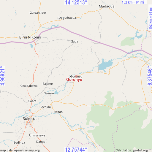
Goronyo GPS coordinates[2]
13° 26' 32.136" North, 5° 40' 20.424" East
| Map corner | latitude | longitude |
|---|---|---|
| Upper-left | 14.12513°, | 4.96921° |
| Center: | 13.44226°, | 5.67234° |
| Lower-right: | 12.75744°, | 6.37546° |
| Map W x H: | 152.1×152.1 km | = 94.5×94.5mi |
| max Lat: | 13.7543° ⇑0.6% North |
| Goronyo: | 13.44226° |
| min Lat: | ⇓99.4% South 4.31231° |
| min Long | Goronyo | max Long |
| 2.73333° | 5.67234° | 14.46552° |
| W 25.9%⇐ | ⇒74.1% E |
Elevation
Elevation of Goronyo is 279 m = 915 ft, and this is 17.5 m = 57 ft below average elevation for this country.
| Max E: |
1599 m = 5246 ft | 50.6% |
| Avg. | 296.5 m = 973 ft | |
| Goronyo | 279 m = 915 ft | |
Min E: |
2 m = 7 ft | 49.4% |
See also: Nigeria elevation on elevation.city.
Geographical zone
Goronyo is located in North Torrid zone (between Equator and Tropic of Cancer). Distance of this Northern Tropic circle is 1111.3 km =690.5 mi to North.| Distance of | km | miles | from Goronyo |
|---|---|---|---|
| North Pole | 8512.4 | 5289.4 | to North |
| Arctic Circle | 5906.5 | 3670.1 | to North |
| Tropic Cancer | 1111.3 | 690.5 | to North |
| Equator | 1494.6 | 928.7 | to South |


Nearby cities:
15 places around Goronyo: (largest is in red/bold)
• Bakura
84.1 km =52.3 mi,  164°
164°
• Binji
86.1 km =53.5 mi,  253°
253°
• Dange
74.4 km =46.2 mi,  208°
208°
• Gada
34.7 km =21.6 mi,  357°
357°
• Gandi
53.8 km =33.4 mi,  171°
171°
• Gidan Madi
77.2 km =48 mi,  257°
257°
• Gwadabawa
47.9 km =29.8 mi, 258°
• Illela
51.6 km =32.1 mi,  308°
308°
• Isa
83.7 km =52 mi,  108°
108°
• Kware
50.5 km =31.4 mi,  240°
240°
• Rabah
39.8 km =24.7 mi, 206°
• Sabon Birni
71.7 km =44.6 mi,  79°
79°
• Sokoto
62.8 km =39 mi,  227°
227°
• Wamako
76.7 km =47.7 mi, 233°
• Wurno
31.8 km =19.8 mi, 237°
Sources, notices
• [Note1] Compared only with cities in Nigeria existing in our database
• [Src1] Map data: © OpenStreetMap contributors (CC-BY-SA)
• [Src2] Other city data from geonames.org with taken over terms of usage.
• [Src3] Geographical zone / Annual Mean Temperature by Robert A. Rohde @ Wikipedia
