Shaffa geodata
Shaffa (Borno) is a populated place; located in Nigeria in Africa/Lagos (GMT+1) time zone. With population of 6,508 people, there are 431 cities with bigger population in this country. Compared to other cities in Nigeria, 69.2% of cities are located further ↓South; 95.5% of cities are located further ←West and 94.4% of cities have lower elevation than Shaffa. Note1


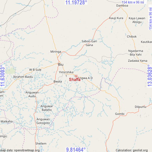
Shaffa GPS coordinates[2]
10° 30' 24.228" North, 12° 19' 59.34" East
| Map corner | latitude | longitude |
|---|---|---|
| Upper-left | 11.19728°, | 11.63003° |
| Center: | 10.50673°, | 12.33315° |
| Lower-right: | 9.81464°, | 13.03628° |
| Map W x H: | 153.7×153.7 km | = 95.5×95.5mi |
| max Lat: | 13.7543° ⇑30.8% North |
| Shaffa: | 10.50673° |
| min Lat: | ⇓69.2% South 4.31231° |
| min Long | Shaffa | max Long |
| 2.73333° | 12.33315° | 14.46552° |
| W 95.5%⇐ | ⇒4.5% E |
Elevation
Elevation of Shaffa is 649 m = 2129 ft, and this is 352.5 m = 1156 ft above average elevation for this country.
| Max E: |
1599 m = 5246 ft | 5.6% |
| Shaffa | 649 m 2129 ft | |
| Avg. | 296.5 m = 973 ft | |
Min E: |
2 m = 7 ft | 94.4% |
See also: Nigeria elevation on elevation.city.
Geographical zone
Shaffa is located in North Torrid zone (between Equator and Tropic of Cancer). Distance of Equator is 1168.2 km =725.9 mi to South.| Distance of | km | miles | from Shaffa |
|---|---|---|---|
| North Pole | 8838.8 | 5492.2 | to North |
| Arctic Circle | 6232.9 | 3872.9 | to North |
| Tropic Cancer | 1437.7 | 893.3 | to North |
| Equator | 1168.2 | 725.9 | to South |


Nearby cities:
15 places around Shaffa: (largest is in red/bold)
• Askira
64.9 km =40.3 mi,  75°
75°
• Azare
5.1 km =3.2 mi,  294°
294°
• Bara
85.6 km =53.2 mi,  303°
303°
• Biu
19.2 km =11.9 mi,  307°
307°
• Briyel
81 km =50.3 mi,  257°
257°
• Chibok
69.1 km =42.9 mi,  54°
54°
• Gombi
58.1 km =36.1 mi,  130°
130°
• Guyuk
80.1 km =49.8 mi,  213°
213°
• Hong
71.8 km =44.6 mi,  115°
115°
• Kwaya Kusar
53.6 km =33.3 mi,  269°
269°
• Miringa
32.2 km =20 mi,  320°
320°
• Shani
43.8 km =27.2 mi,  222°
222°
• Shelleng
76.7 km =47.7 mi, 207°
• Song
82 km =51 mi,  157°
157°
• Wuyo
70.9 km =44.1 mi, 259°
Sources, notices
• [Note1] Compared only with cities in Nigeria existing in our database
• [Src1] Map data: © OpenStreetMap contributors (CC-BY-SA)
• [Src2] Other city data from geonames.org with taken over terms of usage.
• [Src3] Geographical zone / Annual Mean Temperature by Robert A. Rohde @ Wikipedia
