Song geodata
Song (Adamawa) is a seat of a second-order administrative division; located in Nigeria in Africa/Lagos (GMT+1) time zone. In our database, there are 451 cities with bigger population. Compared to other cities in Nigeria, 62.5% of cities are located further ↓South; 96.2% of cities are located further ←West and 54.5% of cities have lower elevation than Song. Note1


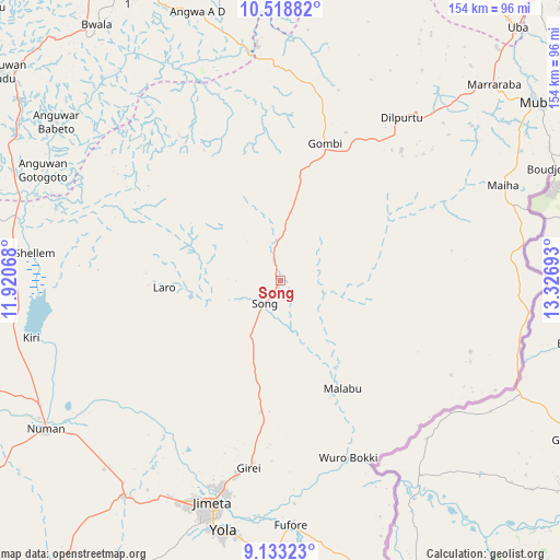
Song GPS coordinates[2]
9° 49' 36.3" North, 12° 37' 25.68" East
| Map corner | latitude | longitude |
|---|---|---|
| Upper-left | 10.51882°, | 11.92068° |
| Center: | 9.82675°, | 12.6238° |
| Lower-right: | 9.13323°, | 13.32693° |
| Map W x H: | 154.1×154.1 km | = 95.8×95.8mi |
| max Lat: | 13.7543° ⇑37.5% North |
| Song: | 9.82675° |
| min Lat: | ⇓62.5% South 4.31231° |
| min Long | Song | max Long |
| 2.73333° | 12.6238° | 14.46552° |
| W 96.2%⇐ | ⇒3.8% E |
Elevation
Elevation of Song is 307 m = 1007 ft, and this is 10.5 m = 34 ft above average elevation for this country.
| Max E: |
1599 m = 5246 ft | 45.5% |
| Song | 307 m 1007 ft | |
| Avg. | 296.5 m = 973 ft | |
Min E: |
2 m = 7 ft | 54.5% |
See also: Nigeria elevation on elevation.city.
Geographical zone
Song is located in North Torrid zone (between Equator and Tropic of Cancer). Distance of Equator is 1092.6 km =678.9 mi to South.| Distance of | km | miles | from Song |
|---|---|---|---|
| North Pole | 8914.4 | 5539.1 | to North |
| Arctic Circle | 6308.5 | 3919.9 | to North |
| Tropic Cancer | 1513.3 | 940.3 | to North |
| Equator | 1092.6 | 678.9 | to South |


Nearby cities:
15 places around Song: (largest is in red/bold)
• Demsa
66.1 km =41.1 mi,  231°
231°
• Fufore
67.3 km =41.8 mi,  177°
177°
• Girei
52 km =32.3 mi,  189°
189°
• Gombi
39.9 km =24.8 mi,  18°
18°
• Guyuk
76.8 km =47.7 mi,  276°
276°
• Holma
47.9 km =29.8 mi,  80°
80°
• Hong
56.1 km =34.9 mi,  36°
36°
• Jimeta
63.5 km =39.5 mi,  196°
196°
• Maiha
67.6 km =42 mi,  73°
73°
• Ngurore
73.1 km =45.4 mi,  215°
215°
• Numan
76.5 km =47.5 mi,  238°
238°
• Shaffa
82 km =51 mi,  337°
337°
• Shani
75.5 km =46.9 mi,  305°
305°
• Shelleng
68.2 km =42.4 mi, 276°
• Yola
70.5 km =43.8 mi, 192°
Sources, notices
• [Note1] Compared only with cities in Nigeria existing in our database
• [Src1] Map data: © OpenStreetMap contributors (CC-BY-SA)
• [Src2] Other city data from geonames.org with taken over terms of usage.
• [Src3] Geographical zone / Annual Mean Temperature by Robert A. Rohde @ Wikipedia
