Shani geodata
Shani (Borno) is a seat of a second-order administrative division; located in Nigeria in Africa/Lagos (GMT+1) time zone. With population of 14,305 people, there are 254 cities with bigger population in this country. Compared to other cities in Nigeria, 65.9% of cities are located further ↓South; 94.4% of cities are located further ←West and 56.4% of cities have higher elevation than Shani. Note1


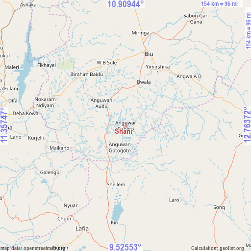
Shani GPS coordinates[2]
10° 13' 5.664" North, 12° 3' 38.124" East
| Map corner | latitude | longitude |
|---|---|---|
| Upper-left | 10.90944°, | 11.35747° |
| Center: | 10.21824°, | 12.06059° |
| Lower-right: | 9.52553°, | 12.76372° |
| Map W x H: | 153.9×153.9 km | = 95.6×95.6mi |
| max Lat: | 13.7543° ⇑34.1% North |
| Shani: | 10.21824° |
| min Lat: | ⇓65.9% South 4.31231° |
| min Long | Shani | max Long |
| 2.73333° | 12.06059° | 14.46552° |
| W 94.4%⇐ | ⇒5.6% E |
Elevation
Elevation of Shani is 239 m = 784 ft, and this is 57.5 m = 189 ft below average elevation for this country.
| Max E: |
1599 m = 5246 ft | 56.4% |
| Avg. | 296.5 m = 973 ft | |
| Shani | 239 m = 784 ft | |
Min E: |
2 m = 7 ft | 43.6% |
See also: Nigeria elevation on elevation.city.
Geographical zone
Shani is located in North Torrid zone (between Equator and Tropic of Cancer). Distance of Equator is 1136.2 km =706 mi to South.| Distance of | km | miles | from Shani |
|---|---|---|---|
| North Pole | 8870.9 | 5512.1 | to North |
| Arctic Circle | 6265 | 3892.9 | to North |
| Tropic Cancer | 1469.8 | 913.3 | to North |
| Equator | 1136.2 | 706 | to South |


Nearby cities:
15 places around Shani: (largest is in red/bold)
• Azare
42.5 km =26.4 mi,  36°
36°
• Biu
46.3 km =28.8 mi,  18°
18°
• Briyel
51.4 km =31.9 mi,  286°
286°
• Deba
73.7 km =45.8 mi,  269°
269°
• Gombi
74.2 km =46.1 mi,  94°
94°
• Guyuk
37.6 km =23.4 mi,  202°
202°
• Hinna
62.2 km =38.6 mi,  278°
278°
• Kwaya Kusar
39.6 km =24.6 mi,  323°
323°
• Lamurde
73.9 km =45.9 mi, 203°
• Miringa
57.8 km =35.9 mi,  9°
9°
• Shaffa
43.8 km =27.2 mi, 42°
• Shelleng
36.3 km =22.6 mi,  189°
189°
• Song
75.5 km =46.9 mi,  125°
125°
• Talasse
50.1 km =31.1 mi,  236°
236°
• Wuyo
43.9 km =27.3 mi,  295°
295°
Sources, notices
• [Note1] Compared only with cities in Nigeria existing in our database
• [Src1] Map data: © OpenStreetMap contributors (CC-BY-SA)
• [Src2] Other city data from geonames.org with taken over terms of usage.
• [Src3] Geographical zone / Annual Mean Temperature by Robert A. Rohde @ Wikipedia
