Sankera geodata
Sankera (Benue) is a seat of a second-order administrative division; located in Nigeria in Africa/Lagos (GMT+1) time zone. In our database, there are 451 cities with bigger population. Compared to other cities in Nigeria, 60.4% of cities are located further ↑North; 81.9% of cities are located further ←West and 59.9% of cities have higher elevation than Sankera. Note1


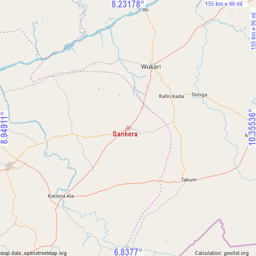
Sankera GPS coordinates[2]
7° 32' 7.08" North, 9° 39' 8.028" East
| Map corner | latitude | longitude |
|---|---|---|
| Upper-left | 8.23178°, | 8.94911° |
| Center: | 7.5353°, | 9.65223° |
| Lower-right: | 6.8377°, | 10.35536° |
| Map W x H: | 155×155 km | = 96.3×96.3mi |
| max Lat: | 13.7543° ⇑60.4% North |
| Sankera: | 7.5353° |
| min Lat: | ⇓39.6% South 4.31231° |
| min Long | Sankera | max Long |
| 2.73333° | 9.65223° | 14.46552° |
| W 81.9%⇐ | ⇒18.1% E |
Elevation
Elevation of Sankera is 208 m = 682 ft, and this is 88.5 m = 290 ft below average elevation for this country.
| Max E: |
1599 m = 5246 ft | 59.9% |
| Avg. | 296.5 m = 973 ft | |
| Sankera | 208 m = 682 ft | |
Min E: |
2 m = 7 ft | 40.1% |
See also: Nigeria elevation on elevation.city.
Geographical zone
Sankera is located in North Torrid zone (between Equator and Tropic of Cancer). Distance of Equator is 837.8 km =520.6 mi to South.| Distance of | km | miles | from Sankera |
|---|---|---|---|
| North Pole | 9169.2 | 5697.5 | to North |
| Arctic Circle | 6563.3 | 4078.2 | to North |
| Tropic Cancer | 1768.1 | 1098.6 | to North |
| Equator | 837.8 | 520.6 | to South |


Nearby cities:
15 places around Sankera: (largest is in red/bold)
• Awe
84.8 km =52.7 mi,  318°
318°
• Buruku
50.1 km =31.1 mi,  260°
260°
• Donga
48 km =29.8 mi,  64°
64°
• Gboko
75.6 km =47 mi,  251°
251°
• Ibi
72.5 km =45 mi,  8°
8°
• Katsina-Ala
57.4 km =35.7 mi,  224°
224°
• Lessel
83.2 km =51.7 mi,  236°
236°
• Lissam
57.5 km =35.7 mi,  130°
130°
• Riti
41.7 km =25.9 mi,  354°
354°
• Takum
47.2 km =29.3 mi, 129°
• Ugba
33.7 km =20.9 mi, 264°
• Wannune
84.6 km =52.6 mi,  272°
272°
• Wukari
39.9 km =24.8 mi,  20°
20°
• Yandev
69.9 km =43.4 mi, 254°
• Zaki Biam
5.6 km =3.5 mi, 235°
Sources, notices
• [Note1] Compared only with cities in Nigeria existing in our database
• [Src1] Map data: © OpenStreetMap contributors (CC-BY-SA)
• [Src2] Other city data from geonames.org with taken over terms of usage.
• [Src3] Geographical zone / Annual Mean Temperature by Robert A. Rohde @ Wikipedia
