Katsina-Ala geodata
Katsina-Ala (Benue) is a seat of a second-order administrative division; located in Nigeria in Africa/Lagos (GMT+1) time zone. With population of 36,722 people, there are 157 cities with bigger population in this country. Compared to other cities in Nigeria, 66.7% of cities are located further ↑North; 79.2% of cities are located further ←West and 69% of cities have higher elevation than Katsina-Ala. Note1


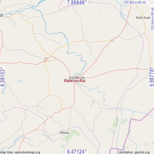
Katsina-Ala GPS coordinates[2]
7° 10' 9.768" North, 9° 17' 4.74" East
| Map corner | latitude | longitude |
|---|---|---|
| Upper-left | 7.86646°, | 8.58153° |
| Center: | 7.16938°, | 9.28465° |
| Lower-right: | 6.47124°, | 9.98778° |
| Map W x H: | 155.1×155.1 km | = 96.4×96.4mi |
| max Lat: | 13.7543° ⇑66.7% North |
| Katsina-Ala: | 7.16938° |
| min Lat: | ⇓33.3% South 4.31231° |
| min Long | Katsina-Ala | max Long |
| 2.73333° | 9.28465° | 14.46552° |
| W 79.2%⇐ | ⇒20.8% E |
Elevation
Elevation of Katsina-Ala is 152 m = 499 ft, and this is 144.5 m = 474 ft below average elevation for this country.
| Max E: |
1599 m = 5246 ft | 69% |
| Avg. | 296.5 m = 973 ft | |
| Katsina-Ala | 152 m = 499 ft | |
Min E: |
2 m = 7 ft | 31% |
See also: Nigeria elevation on elevation.city.
Geographical zone
Katsina-Ala is located in North Torrid zone (between Equator and Tropic of Cancer). Distance of Equator is 797.2 km =495.4 mi to South.| Distance of | km | miles | from Katsina-Ala |
|---|---|---|---|
| North Pole | 9209.9 | 5722.8 | to North |
| Arctic Circle | 6604 | 4103.5 | to North |
| Tropic Cancer | 1808.8 | 1123.9 | to North |
| Equator | 797.2 | 495.4 | to South |


Nearby cities:
15 places around Katsina-Ala: (largest is in red/bold)
• Abuochiche
65.1 km =40.5 mi,  215°
215°
• Adikpo
31.6 km =19.6 mi,  190°
190°
• Buruku
33.5 km =20.8 mi,  344°
344°
• Gakem
55 km =34.2 mi, 216°
• Gboko
35.6 km =22.1 mi,  298°
298°
• Lessel
29.6 km =18.4 mi,  260°
260°
• Obudu
57.3 km =35.6 mi, 193°
• Sankera
57.4 km =35.7 mi,  44°
44°
• Sankwala
69.5 km =43.2 mi, 185°
• Tse-Agberagba
69.1 km =42.9 mi, 261°
• Ugba
38.2 km =23.7 mi,  10°
10°
• Vandeikya
49 km =30.4 mi,  209°
209°
• Wannune
62.1 km =38.6 mi,  314°
314°
• Yandev
34.3 km =21.3 mi, 308°
• Zaki Biam
51.9 km =32.2 mi, 43°
Sources, notices
• [Note1] Compared only with cities in Nigeria existing in our database
• [Src1] Map data: © OpenStreetMap contributors (CC-BY-SA)
• [Src2] Other city data from geonames.org with taken over terms of usage.
• [Src3] Geographical zone / Annual Mean Temperature by Robert A. Rohde @ Wikipedia
