Lissam geodata
Lissam (Taraba) is a seat of a second-order administrative division; located in Nigeria in Africa/Lagos (GMT+1) time zone. In our database, there are 451 cities with bigger population. Compared to other cities in Nigeria, 66.2% of cities are located further ↑North; 85% of cities are located further ←West and 51.9% of cities have higher elevation than Lissam. Note1


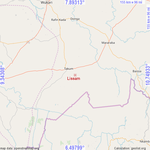
Lissam GPS coordinates[2]
7° 11' 45.96" North, 10° 2' 46.32" East
| Map corner | latitude | longitude |
|---|---|---|
| Upper-left | 7.89313°, | 9.34308° |
| Center: | 7.1961°, | 10.0462° |
| Lower-right: | 6.49799°, | 10.74933° |
| Map W x H: | 155.1×155.1 km | = 96.4×96.4mi |
| max Lat: | 13.7543° ⇑66.2% North |
| Lissam: | 7.1961° |
| min Lat: | ⇓33.8% South 4.31231° |
| min Long | Lissam | max Long |
| 2.73333° | 10.0462° | 14.46552° |
| W 85%⇐ | ⇒15% E |
Elevation
Elevation of Lissam is 271 m = 889 ft, and this is 25.5 m = 84 ft below average elevation for this country.
| Max E: |
1599 m = 5246 ft | 51.9% |
| Avg. | 296.5 m = 973 ft | |
| Lissam | 271 m = 889 ft | |
Min E: |
2 m = 7 ft | 48.1% |
See also: Nigeria elevation on elevation.city.
Geographical zone
Lissam is located in North Torrid zone (between Equator and Tropic of Cancer). Distance of Equator is 800.1 km =497.2 mi to South.| Distance of | km | miles | from Lissam |
|---|---|---|---|
| North Pole | 9206.9 | 5720.9 | to North |
| Arctic Circle | 6601 | 4101.7 | to North |
| Tropic Cancer | 1805.8 | 1122.1 | to North |
| Equator | 800.1 | 497.2 | to South |


Nearby cities:
15 places around Lissam: (largest is in red/bold)
• Adikpo
95.9 km =59.6 mi,  249°
249°
• Baissa
63.9 km =39.7 mi,  86°
86°
• Buruku
97.3 km =60.5 mi,  287°
287°
• Donga
58.4 km =36.3 mi,  359°
359°
• Ibi
114.5 km =71.1 mi,  343°
343°
• Katsina-Ala
84.1 km =52.3 mi,  267°
267°
• Lessel
113.5 km =70.5 mi, 266°
• Obudu
113.6 km =70.6 mi,  238°
238°
• Riti
92.3 km =57.4 mi,  329°
329°
• Sankera
57.5 km =35.7 mi,  310°
310°
• Takum
10.5 km =6.5 mi,  318°
318°
• Ugba
84.4 km =52.4 mi, 294°
• Wukari
80.7 km =50.1 mi, 338°
• Yandev
112.3 km =69.8 mi,  279°
279°
• Zaki Biam
59.2 km =36.8 mi, 305°
Sources, notices
• [Note1] Compared only with cities in Nigeria existing in our database
• [Src1] Map data: © OpenStreetMap contributors (CC-BY-SA)
• [Src2] Other city data from geonames.org with taken over terms of usage.
• [Src3] Geographical zone / Annual Mean Temperature by Robert A. Rohde @ Wikipedia
