Donga geodata
Donga (Taraba) is a seat of a second-order administrative division; located in Nigeria in Africa/Lagos (GMT+1) time zone. In our database, there are 451 cities with bigger population. Compared to other cities in Nigeria, 57.5% of cities are located further ↑North; 84.9% of cities are located further ←West and 72.4% of cities have higher elevation than Donga. Note1


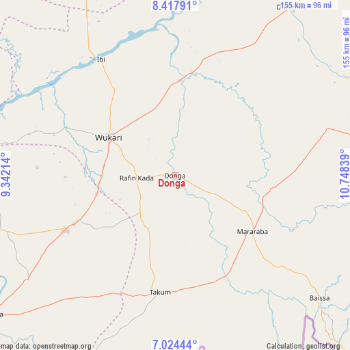
Donga GPS coordinates[2]
7° 43' 18.3" North, 10° 2' 42.936" East
| Map corner | latitude | longitude |
|---|---|---|
| Upper-left | 8.41791°, | 9.34214° |
| Center: | 7.72175°, | 10.04526° |
| Lower-right: | 7.02444°, | 10.74839° |
| Map W x H: | 154.9×154.9 km | = 96.3×96.3mi |
| max Lat: | 13.7543° ⇑57.5% North |
| Donga: | 7.72175° |
| min Lat: | ⇓42.5% South 4.31231° |
| min Long | Donga | max Long |
| 2.73333° | 10.04526° | 14.46552° |
| W 84.9%⇐ | ⇒15.1% E |
Elevation
Elevation of Donga is 136 m = 446 ft, and this is 160.5 m = 527 ft below average elevation for this country.
| Max E: |
1599 m = 5246 ft | 72.4% |
| Avg. | 296.5 m = 973 ft | |
| Donga | 136 m = 446 ft | |
Min E: |
2 m = 7 ft | 27.6% |
See also: Nigeria elevation on elevation.city.
Geographical zone
Donga is located in North Torrid zone (between Equator and Tropic of Cancer). Distance of Equator is 858.6 km =533.5 mi to South.| Distance of | km | miles | from Donga |
|---|---|---|---|
| North Pole | 9148.5 | 5684.6 | to North |
| Arctic Circle | 6542.6 | 4065.4 | to North |
| Tropic Cancer | 1747.3 | 1085.7 | to North |
| Equator | 858.6 | 533.5 | to South |


Nearby cities:
15 places around Donga: (largest is in red/bold)
• Awe
108.4 km =67.4 mi,  293°
293°
• Baissa
84 km =52.2 mi,  130°
130°
• Beli
103.2 km =64.1 mi,  81°
81°
• Buruku
97.1 km =60.3 mi,  252°
252°
• Gassol
100.7 km =62.6 mi,  26°
26°
• Ibi
60.9 km =37.8 mi,  327°
327°
• Katsina-Ala
103.9 km =64.6 mi,  233°
233°
• Lissam
58.4 km =36.3 mi,  179°
179°
• Mabudi
115.7 km =71.9 mi,  345°
345°
• Riti
51.6 km =32.1 mi, 293°
• Sankera
48 km =29.8 mi,  244°
244°
• Takum
51.1 km =31.8 mi,  187°
187°
• Ugba
80.5 km =50 mi, 252°
• Wukari
33.8 km =21 mi,  299°
299°
• Zaki Biam
53.6 km =33.3 mi, 243°
Sources, notices
• [Note1] Compared only with cities in Nigeria existing in our database
• [Src1] Map data: © OpenStreetMap contributors (CC-BY-SA)
• [Src2] Other city data from geonames.org with taken over terms of usage.
• [Src3] Geographical zone / Annual Mean Temperature by Robert A. Rohde @ Wikipedia
