Akure geodata
Akure (Ondo) is a seat of a first-order administrative division; located in Nigeria in Africa/Lagos (GMT+1) time zone. With population of 420,594 people, there are 24 cities with bigger population in this country. Compared to other cities in Nigeria, 65.2% of cities are located further ↑North; 78.9% of cities are located further →East and 61.2% of cities have lower elevation than Akure. Note1


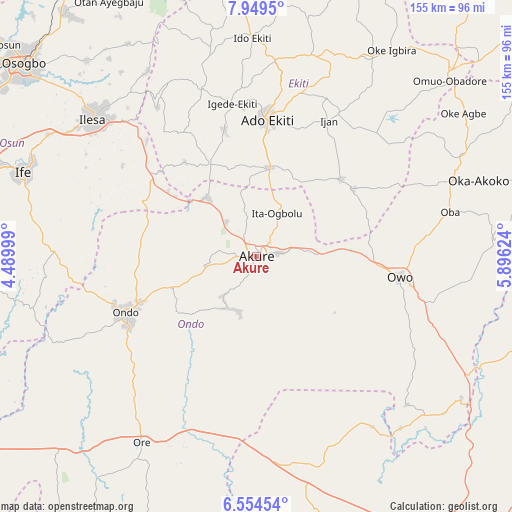
Akure GPS coordinates[2]
7° 15' 9.216" North, 5° 11' 35.232" East
| Map corner | latitude | longitude |
|---|---|---|
| Upper-left | 7.9495°, | 4.48999° |
| Center: | 7.25256°, | 5.19312° |
| Lower-right: | 6.55454°, | 5.89624° |
| Map W x H: | 155.1×155.1 km | = 96.4×96.4mi |
| max Lat: | 13.7543° ⇑65.2% North |
| Akure: | 7.25256° |
| min Lat: | ⇓34.8% South 4.31231° |
| min Long | Akure | max Long |
| 2.73333° | 5.19312° | 14.46552° |
| W 21.1%⇐ | ⇒78.9% E |
Elevation
Elevation of Akure is 353 m = 1158 ft, and this is 56.5 m = 185 ft above average elevation for this country.
| Max E: |
1599 m = 5246 ft | 38.8% |
| Akure | 353 m 1158 ft | |
| Avg. | 296.5 m = 973 ft | |
Min E: |
2 m = 7 ft | 61.2% |
See also: Akure elevation on elevation.city.
Geographical zone
Akure is located in North Torrid zone (between Equator and Tropic of Cancer). Distance of Equator is 806.4 km =501.1 mi to South.| Distance of | km | miles | from Akure |
|---|---|---|---|
| North Pole | 9200.7 | 5717 | to North |
| Arctic Circle | 6594.8 | 4097.8 | to North |
| Tropic Cancer | 1799.5 | 1118.2 | to North |
| Equator | 806.4 | 501.1 | to South |


Nearby cities:
15 places around Akure: (largest is in red/bold)
• Ado-Ekiti
41.3 km =25.7 mi,  4°
4°
• Bolorunduro
27.1 km =16.8 mi,  249°
249°
• Emure-Ekiti
35.8 km =22.2 mi,  55°
55°
• Idanre
17.7 km =11 mi,  208°
208°
• Igbara-Odo
31.3 km =19.4 mi,  332°
332°
• Igbara-Oke
23.1 km =14.4 mi,  319°
319°
• Iju
17.4 km =10.8 mi,  24°
24°
• Ikere-Ekiti
27.5 km =17.1 mi,  8°
8°
• Ilare
14 km =8.7 mi, 321°
• Ilawe-Ekiti
39.7 km =24.7 mi,  345°
345°
• Ile-Oluji
36 km =22.4 mi,  263°
263°
• Ise-Ekiti
34.7 km =21.6 mi,  47°
47°
• Ita-Ogbolu
14.2 km =8.8 mi, 24°
• Ondo
43.3 km =26.9 mi, 245°
• Owena
19.9 km =12.4 mi, 250°
Sources, notices
• [Note1] Compared only with cities in Nigeria existing in our database
• [Src1] Map data: © OpenStreetMap contributors (CC-BY-SA)
• [Src2] Other city data from geonames.org with taken over terms of usage.
• [Src3] Geographical zone / Annual Mean Temperature by Robert A. Rohde @ Wikipedia
