Umuneke-Ngor geodata
Umuneke-Ngor (Imo) is a seat of a second-order administrative division; located in Nigeria in Africa/Lagos (GMT+1) time zone. In our database, there are 451 cities with bigger population. Compared to other cities in Nigeria, 91.4% of cities are located further ↑North; 53.3% of cities are located further →East and 83.2% of cities have higher elevation than Umuneke-Ngor. Note1


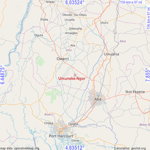
Umuneke-Ngor GPS coordinates[2]
5° 20' 8.088" North, 7° 9' 6.732" East
| Map corner | latitude | longitude |
|---|---|---|
| Upper-left | 6.03524°, | 6.44875° |
| Center: | 5.33558°, | 7.15187° |
| Lower-right: | 4.63512°, | 7.855° |
| Map W x H: | 155.7×155.7 km | = 96.7×96.7mi |
| max Lat: | 13.7543° ⇑91.4% North |
| Umuneke-Ngor: | 5.33558° |
| min Lat: | ⇓8.6% South 4.31231° |
| min Long | Umuneke-Ngor | max Long |
| 2.73333° | 7.15187° | 14.46552° |
| W 46.7%⇐ | ⇒53.3% E |
Elevation
Elevation of Umuneke-Ngor is 66 m = 217 ft, and this is 230.5 m = 756 ft below average elevation for this country.
| Max E: |
1599 m = 5246 ft | 83.2% |
| Avg. | 296.5 m = 973 ft | |
| Umuneke-Ngor | 66 m = 217 ft | |
Min E: |
2 m = 7 ft | 16.8% |
See also: Nigeria elevation on elevation.city.
Geographical zone
Umuneke-Ngor is located in North Torrid zone (between Equator and Tropic of Cancer). Distance of Equator is 593.3 km =368.7 mi to South.| Distance of | km | miles | from Umuneke-Ngor |
|---|---|---|---|
| North Pole | 9413.8 | 5849.5 | to North |
| Arctic Circle | 6807.9 | 4230.2 | to North |
| Tropic Cancer | 2012.7 | 1250.6 | to North |
| Equator | 593.3 | 368.7 | to South |


Nearby cities:
15 places around Umuneke-Ngor: (largest is in red/bold)
• Aba
34.8 km =21.6 mi,  136°
136°
• Aboh
20.5 km =12.7 mi,  40°
40°
• Afor-Oru
26.2 km =16.3 mi,  29°
29°
• Eberi
28.6 km =17.8 mi,  161°
161°
• Iho
28 km =17.4 mi,  347°
347°
• Isinweke
38.5 km =23.9 mi, 34°
• Itu
24.4 km =15.2 mi,  54°
54°
• Nwaorieubi
31.2 km =19.4 mi,  331°
331°
• Okehi
21.9 km =13.6 mi,  183°
183°
• Okpuala-Ngwa
26.2 km =16.3 mi,  84°
84°
• Omoba
30 km =18.6 mi,  110°
110°
• Orodo
33.9 km =21.1 mi,  337°
337°
• Osisioma
27.2 km =16.9 mi, 135°
• Owerri
21.1 km =13.1 mi,  321°
321°
• Umuguma
25.3 km =15.7 mi,  305°
305°
Sources, notices
• [Note1] Compared only with cities in Nigeria existing in our database
• [Src1] Map data: © OpenStreetMap contributors (CC-BY-SA)
• [Src2] Other city data from geonames.org with taken over terms of usage.
• [Src3] Geographical zone / Annual Mean Temperature by Robert A. Rohde @ Wikipedia
