Egbema geodata
Egbema (Imo) is a seat of a second-order administrative division; located in Nigeria in Africa/Lagos (GMT+1) time zone. In our database, there are 451 cities with bigger population. Compared to other cities in Nigeria, 89.4% of cities are located further ↑North; 61.5% of cities are located further →East and 92.4% of cities have higher elevation than Egbema. Note1


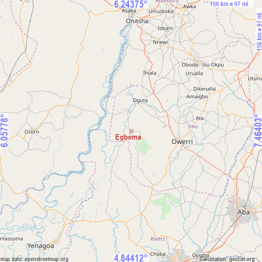
Egbema GPS coordinates[2]
5° 32' 39.66" North, 6° 45' 39.24" East
| Map corner | latitude | longitude |
|---|---|---|
| Upper-left | 6.24375°, | 6.05778° |
| Center: | 5.54435°, | 6.7609° |
| Lower-right: | 4.84412°, | 7.46403° |
| Map W x H: | 155.6×155.6 km | = 96.7×96.7mi |
| max Lat: | 13.7543° ⇑89.4% North |
| Egbema: | 5.54435° |
| min Lat: | ⇓10.6% South 4.31231° |
| min Long | Egbema | max Long |
| 2.73333° | 6.7609° | 14.46552° |
| W 38.5%⇐ | ⇒61.5% E |
Elevation
Elevation of Egbema is 20 m = 66 ft, and this is 276.5 m = 907 ft below average elevation for this country.
| Max E: |
1599 m = 5246 ft | 92.4% |
| Avg. | 296.5 m = 973 ft | |
| Egbema | 20 m = 66 ft | |
Min E: |
2 m = 7 ft | 7.6% |
See also: Nigeria elevation on elevation.city.
Geographical zone
Egbema is located in North Torrid zone (between Equator and Tropic of Cancer). Distance of Equator is 616.5 km =383.1 mi to South.| Distance of | km | miles | from Egbema |
|---|---|---|---|
| North Pole | 9390.6 | 5835 | to North |
| Arctic Circle | 6784.7 | 4215.8 | to North |
| Tropic Cancer | 1989.4 | 1236.2 | to North |
| Equator | 616.5 | 383.1 | to South |


Nearby cities:
15 places around Egbema: (largest is in red/bold)
• Aboh
26 km =16.2 mi,  270°
270°
• Awo-Idemili
36.7 km =22.8 mi,  31°
31°
• Ihiala
36.2 km =22.5 mi,  17°
17°
• Iho
37.6 km =23.4 mi,  83°
83°
• Kwale
40.5 km =25.2 mi,  296°
296°
• Mgbidi
25.2 km =15.7 mi, 34°
• Nnenasa
34.9 km =21.7 mi,  53°
53°
• Nwaorieubi
28.6 km =17.8 mi, 81°
• Oguta
19.2 km =11.9 mi, 16°
• Omoku
25.1 km =15.6 mi,  207°
207°
• Orodo
31.2 km =19.4 mi, 75°
• Owerri
30.9 km =19.2 mi,  102°
102°
• Umuguma
24.2 km =15 mi,  110°
110°
• Umumma
31.3 km =19.4 mi,  40°
40°
• Umundugba
37.4 km =23.2 mi,  66°
66°
Sources, notices
• [Note1] Compared only with cities in Nigeria existing in our database
• [Src1] Map data: © OpenStreetMap contributors (CC-BY-SA)
• [Src2] Other city data from geonames.org with taken over terms of usage.
• [Src3] Geographical zone / Annual Mean Temperature by Robert A. Rohde @ Wikipedia
