Otor-Udu geodata
Otor-Udu (Delta) is a seat of a second-order administrative division; located in Nigeria in Africa/Lagos (GMT+1) time zone. In our database, there are 451 cities with bigger population. Compared to other cities in Nigeria, 90.5% of cities are located further ↑North; 71.9% of cities are located further →East and 97.1% of cities have higher elevation than Otor-Udu. Note1


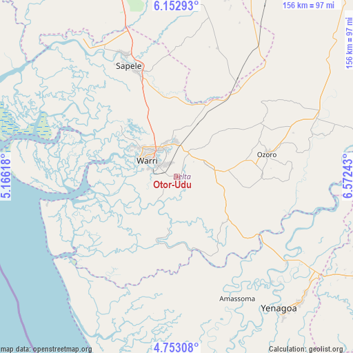
Otor-Udu GPS coordinates[2]
5° 27' 12.276" North, 5° 52' 9.48" East
| Map corner | latitude | longitude |
|---|---|---|
| Upper-left | 6.15293°, | 5.16618° |
| Center: | 5.45341°, | 5.8693° |
| Lower-right: | 4.75308°, | 6.57243° |
| Map W x H: | 155.6×155.7 km | = 96.7×96.7mi |
| max Lat: | 13.7543° ⇑90.5% North |
| Otor-Udu: | 5.45341° |
| min Lat: | ⇓9.5% South 4.31231° |
| min Long | Otor-Udu | max Long |
| 2.73333° | 5.8693° | 14.46552° |
| W 28.1%⇐ | ⇒71.9% E |
Elevation
Elevation of Otor-Udu is 8 m = 26 ft, and this is 288.5 m = 947 ft below average elevation for this country.
| Max E: |
1599 m = 5246 ft | 97.1% |
| Avg. | 296.5 m = 973 ft | |
| Otor-Udu | 8 m = 26 ft | |
Min E: |
2 m = 7 ft | 2.9% |
See also: Nigeria elevation on elevation.city.
Geographical zone
Otor-Udu is located in North Torrid zone (between Equator and Tropic of Cancer). Distance of Equator is 606.4 km =376.8 mi to South.| Distance of | km | miles | from Otor-Udu |
|---|---|---|---|
| North Pole | 9400.7 | 5841.3 | to North |
| Arctic Circle | 6794.8 | 4222.1 | to North |
| Tropic Cancer | 1999.6 | 1242.5 | to North |
| Equator | 606.4 | 376.8 | to South |


Nearby cities:
15 places around Otor-Udu: (largest is in red/bold)
• Abraka
45.6 km =28.3 mi,  34°
34°
• Bomadi
33.1 km =20.6 mi,  169°
169°
• Burutu
41.5 km =25.8 mi,  254°
254°
• Effurun
14.8 km =9.2 mi,  320°
320°
• Ekeremor
45 km =28 mi,  192°
192°
• Isiokolo
21.5 km =13.4 mi,  42°
42°
• Oleh
37.3 km =23.2 mi,  88°
88°
• Orerokpe
20.6 km =12.8 mi,  6°
6°
• Otu-Jeremi
2 km =1.2 mi,  149°
149°
• Ozoro
40.9 km =25.4 mi,  75°
75°
• Patani
43.5 km =27 mi,  125°
125°
• Sagbama
48.8 km =30.3 mi, 132°
• Sapele
53.4 km =33.2 mi,  336°
336°
• Ughelli
15.4 km =9.6 mi,  74°
74°
• Warri
15 km =9.3 mi,  298°
298°
Sources, notices
• [Note1] Compared only with cities in Nigeria existing in our database
• [Src1] Map data: © OpenStreetMap contributors (CC-BY-SA)
• [Src2] Other city data from geonames.org with taken over terms of usage.
• [Src3] Geographical zone / Annual Mean Temperature by Robert A. Rohde @ Wikipedia
