Orerokpe geodata
Orerokpe (Delta) is a seat of a second-order administrative division; located in Nigeria in Africa/Lagos (GMT+1) time zone. With population of 5,893 people, there are 443 cities with bigger population in this country. Compared to other cities in Nigeria, 88% of cities are located further ↑North; 71.6% of cities are located further →East and 94.1% of cities have higher elevation than Orerokpe. Note1


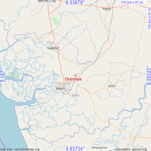
Orerokpe GPS coordinates[2]
5° 38' 14.892" North, 5° 53' 24.468" East
| Map corner | latitude | longitude |
|---|---|---|
| Upper-left | 6.33676°, | 5.187° |
| Center: | 5.63747°, | 5.89013° |
| Lower-right: | 4.93734°, | 6.59325° |
| Map W x H: | 155.6×155.6 km | = 96.7×96.7mi |
| max Lat: | 13.7543° ⇑88% North |
| Orerokpe: | 5.63747° |
| min Lat: | ⇓12% South 4.31231° |
| min Long | Orerokpe | max Long |
| 2.73333° | 5.89013° | 14.46552° |
| W 28.4%⇐ | ⇒71.6% E |
Elevation
Elevation of Orerokpe is 14 m = 46 ft, and this is 282.5 m = 927 ft below average elevation for this country.
| Max E: |
1599 m = 5246 ft | 94.1% |
| Avg. | 296.5 m = 973 ft | |
| Orerokpe | 14 m = 46 ft | |
Min E: |
2 m = 7 ft | 5.9% |
See also: Nigeria elevation on elevation.city.
Geographical zone
Orerokpe is located in North Torrid zone (between Equator and Tropic of Cancer). Distance of Equator is 626.8 km =389.5 mi to South.| Distance of | km | miles | from Orerokpe |
|---|---|---|---|
| North Pole | 9380.2 | 5828.6 | to North |
| Arctic Circle | 6774.3 | 4209.4 | to North |
| Tropic Cancer | 1979.1 | 1229.8 | to North |
| Equator | 626.8 | 389.5 | to South |


Nearby cities:
15 places around Orerokpe: (largest is in red/bold)
• Abraka
29.2 km =18.1 mi,  54°
54°
• Bomadi
53.1 km =33 mi,  175°
175°
• Burutu
52.8 km =32.8 mi,  233°
233°
• Effurun
14.8 km =9.2 mi, 232°
• Isiokolo
13 km =8.1 mi,  110°
110°
• Obiaruku
37.2 km =23.1 mi, 51°
• Oghara
41.4 km =25.7 mi,  323°
323°
• Oleh
40.1 km =24.9 mi,  119°
119°
• Otor-Udu
20.6 km =12.8 mi,  186°
186°
• Otu-Jeremi
22.2 km =13.8 mi, 183°
• Ozoro
38.6 km =24 mi, 105°
• Patani
56.4 km =35 mi,  143°
143°
• Sapele
37 km =23 mi, 320°
• Ughelli
20.7 km =12.9 mi, 142°
• Warri
20.5 km =12.7 mi, 229°
Sources, notices
• [Note1] Compared only with cities in Nigeria existing in our database
• [Src1] Map data: © OpenStreetMap contributors (CC-BY-SA)
• [Src2] Other city data from geonames.org with taken over terms of usage.
• [Src3] Geographical zone / Annual Mean Temperature by Robert A. Rohde @ Wikipedia
