Ughelli geodata
Ughelli (Delta) is a seat of a second-order administrative division; located in Nigeria in Africa/Lagos (GMT+1) time zone. With population of 79,986 people, there are 110 cities with bigger population in this country. Compared to other cities in Nigeria, 89.8% of cities are located further ↑North; 70.5% of cities are located further →East and 94.7% of cities have higher elevation than Ughelli. Note1


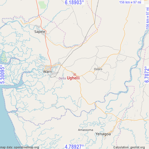
Ughelli GPS coordinates[2]
5° 29' 22.416" North, 6° 0' 14.652" East
| Map corner | latitude | longitude |
|---|---|---|
| Upper-left | 6.18903°, | 5.30095° |
| Center: | 5.48956°, | 6.00407° |
| Lower-right: | 4.78927°, | 6.7072° |
| Map W x H: | 155.6×155.6 km | = 96.7×96.7mi |
| max Lat: | 13.7543° ⇑89.8% North |
| Ughelli: | 5.48956° |
| min Lat: | ⇓10.2% South 4.31231° |
| min Long | Ughelli | max Long |
| 2.73333° | 6.00407° | 14.46552° |
| W 29.5%⇐ | ⇒70.5% E |
Elevation
Elevation of Ughelli is 13 m = 43 ft, and this is 283.5 m = 930 ft below average elevation for this country.
| Max E: |
1599 m = 5246 ft | 94.7% |
| Avg. | 296.5 m = 973 ft | |
| Ughelli | 13 m = 43 ft | |
Min E: |
2 m = 7 ft | 5.3% |
See also: Ughelli elevation on elevation.city.
Geographical zone
Ughelli is located in North Torrid zone (between Equator and Tropic of Cancer). Distance of Equator is 610.4 km =379.3 mi to South.| Distance of | km | miles | from Ughelli |
|---|---|---|---|
| North Pole | 9396.7 | 5838.8 | to North |
| Arctic Circle | 6790.8 | 4219.6 | to North |
| Tropic Cancer | 1995.5 | 1239.9 | to North |
| Equator | 610.4 | 379.3 | to South |


Nearby cities:
15 places around Ughelli: (largest is in red/bold)
• Abraka
35.2 km =21.9 mi,  18°
18°
• Bomadi
37.6 km =23.4 mi,  193°
193°
• Effurun
25.4 km =15.8 mi,  286°
286°
• Isiokolo
11.8 km =7.3 mi,  357°
357°
• Kaiama
52.6 km =32.7 mi,  141°
141°
• Kwale
53.4 km =33.2 mi,  62°
62°
• Obiaruku
43 km =26.7 mi, 22°
• Oleh
22.6 km =14 mi,  97°
97°
• Orerokpe
20.7 km =12.9 mi,  322°
322°
• Otor-Udu
15.4 km =9.6 mi,  254°
254°
• Otu-Jeremi
15 km =9.3 mi, 247°
• Ozoro
25.4 km =15.8 mi,  75°
75°
• Patani
35.6 km =22.1 mi, 144°
• Sagbama
42.5 km =26.4 mi,  149°
149°
• Warri
28.3 km =17.6 mi,  276°
276°
Sources, notices
• [Note1] Compared only with cities in Nigeria existing in our database
• [Src1] Map data: © OpenStreetMap contributors (CC-BY-SA)
• [Src2] Other city data from geonames.org with taken over terms of usage.
• [Src3] Geographical zone / Annual Mean Temperature by Robert A. Rohde @ Wikipedia
