Warri geodata
Warri (Delta) is a seat of a second-order administrative division; located in Nigeria in Africa/Lagos (GMT+1) time zone. With population of 536,023 people, there are 17 cities with bigger population in this country. Compared to other cities in Nigeria, 89.7% of cities are located further ↑North; 73.5% of cities are located further →East and 99.1% of cities have higher elevation than Warri. Note1


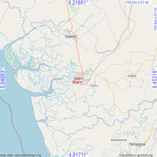
Warri GPS coordinates[2]
5° 31' 2.532" North, 5° 45' 0.216" East
| Map corner | latitude | longitude |
|---|---|---|
| Upper-left | 6.21681°, | 5.04693° |
| Center: | 5.51737°, | 5.75006° |
| Lower-right: | 4.81711°, | 6.45318° |
| Map W x H: | 155.6×155.6 km | = 96.7×96.7mi |
| max Lat: | 13.7543° ⇑89.7% North |
| Warri: | 5.51737° |
| min Lat: | ⇓10.3% South 4.31231° |
| min Long | Warri | max Long |
| 2.73333° | 5.75006° | 14.46552° |
| W 26.5%⇐ | ⇒73.5% E |
Elevation
Elevation of Warri is 6 m = 20 ft, and this is 290.5 m = 953 ft below average elevation for this country.
| Max E: |
1599 m = 5246 ft | 99.1% |
| Avg. | 296.5 m = 973 ft | |
| Warri | 6 m = 20 ft | |
Min E: |
2 m = 7 ft | 0.9% |
See also: Warri elevation on elevation.city.
Geographical zone
Warri is located in North Torrid zone (between Equator and Tropic of Cancer). Distance of Equator is 613.5 km =381.2 mi to South.| Distance of | km | miles | from Warri |
|---|---|---|---|
| North Pole | 9393.6 | 5836.9 | to North |
| Arctic Circle | 6787.7 | 4217.7 | to North |
| Tropic Cancer | 1992.4 | 1238 | to North |
| Equator | 613.5 | 381.2 | to South |


Nearby cities:
15 places around Warri: (largest is in red/bold)
• Abraka
49.6 km =30.8 mi,  52°
52°
• Bomadi
44.1 km =27.4 mi,  154°
154°
• Burutu
32.4 km =20.1 mi,  235°
235°
• Effurun
5.8 km =3.6 mi,  41°
41°
• Ekeremor
51.2 km =31.8 mi,  176°
176°
• Isiokolo
29 km =18 mi,  72°
72°
• Obiaruku
57.7 km =35.9 mi, 50°
• Oghara
47.4 km =29.5 mi,  348°
348°
• Oleh
50.9 km =31.6 mi,  96°
96°
• Orerokpe
20.5 km =12.7 mi, 49°
• Otor-Udu
15 km =9.3 mi,  118°
118°
• Otu-Jeremi
16.7 km =10.4 mi, 121°
• Ozoro
52.8 km =32.8 mi,  86°
86°
• Sapele
42.7 km =26.5 mi, 349°
• Ughelli
28.3 km =17.6 mi, 96°
Sources, notices
• [Note1] Compared only with cities in Nigeria existing in our database
• [Src1] Map data: © OpenStreetMap contributors (CC-BY-SA)
• [Src2] Other city data from geonames.org with taken over terms of usage.
• [Src3] Geographical zone / Annual Mean Temperature by Robert A. Rohde @ Wikipedia
