Abraka geodata
Abraka (Delta) is a populated place; located in Nigeria in Africa/Lagos (GMT+1) time zone. With population of 6,940 people, there are 419 cities with bigger population in this country. Compared to other cities in Nigeria, 86.3% of cities are located further ↑North; 69.4% of cities are located further →East and 90.2% of cities have higher elevation than Abraka. Note1


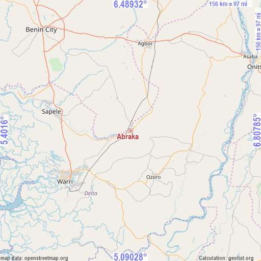
Abraka GPS coordinates[2]
5° 47' 24.828" North, 6° 6' 17.028" East
| Map corner | latitude | longitude |
|---|---|---|
| Upper-left | 6.48932°, | 5.4016° |
| Center: | 5.79023°, | 6.10473° |
| Lower-right: | 5.09028°, | 6.80785° |
| Map W x H: | 155.6×155.6 km | = 96.7×96.7mi |
| max Lat: | 13.7543° ⇑86.3% North |
| Abraka: | 5.79023° |
| min Lat: | ⇓13.7% South 4.31231° |
| min Long | Abraka | max Long |
| 2.73333° | 6.10473° | 14.46552° |
| W 30.6%⇐ | ⇒69.4% E |
Elevation
Elevation of Abraka is 29 m = 95 ft, and this is 267.5 m = 878 ft below average elevation for this country.
| Max E: |
1599 m = 5246 ft | 90.2% |
| Avg. | 296.5 m = 973 ft | |
| Abraka | 29 m = 95 ft | |
Min E: |
2 m = 7 ft | 9.8% |
See also: Nigeria elevation on elevation.city.
Geographical zone
Abraka is located in North Torrid zone (between Equator and Tropic of Cancer). Distance of Equator is 643.8 km =400 mi to South.| Distance of | km | miles | from Abraka |
|---|---|---|---|
| North Pole | 9363.2 | 5818 | to North |
| Arctic Circle | 6757.4 | 4198.9 | to North |
| Tropic Cancer | 1962.1 | 1219.2 | to North |
| Equator | 643.8 | 400 | to South |


Nearby cities:
15 places around Abraka: (largest is in red/bold)
• Agbor
52.5 km =32.6 mi,  10°
10°
• Effurun
43.9 km =27.3 mi,  233°
233°
• Isiokolo
24.5 km =15.2 mi,  208°
208°
• Kwale
37.6 km =23.4 mi,  104°
104°
• Obiaruku
8.2 km =5.1 mi,  40°
40°
• Oghara
51.1 km =31.8 mi,  288°
288°
• Oleh
38.2 km =23.7 mi,  162°
162°
• Orerokpe
29.2 km =18.1 mi, 234°
• Otor-Udu
45.6 km =28.3 mi, 214°
• Otu-Jeremi
46.5 km =28.9 mi, 212°
• Owa-Oyibu
44.9 km =27.9 mi, 13°
• Ozoro
30.2 km =18.8 mi,  153°
153°
• Sapele
48.7 km =30.3 mi,  283°
283°
• Ughelli
35.2 km =21.9 mi,  198°
198°
• Warri
49.6 km =30.8 mi, 232°
Sources, notices
• [Note1] Compared only with cities in Nigeria existing in our database
• [Src1] Map data: © OpenStreetMap contributors (CC-BY-SA)
• [Src2] Other city data from geonames.org with taken over terms of usage.
• [Src3] Geographical zone / Annual Mean Temperature by Robert A. Rohde @ Wikipedia
