Okigwe geodata
Okigwe (Imo) is a seat of a second-order administrative division; located in Nigeria in Africa/Lagos (GMT+1) time zone. With population of 115,499 people, there are 73 cities with bigger population in this country. Compared to other cities in Nigeria, 85.9% of cities are located further ↑North; 50.5% of cities are located further ←West and 68% of cities have higher elevation than Okigwe. Note1


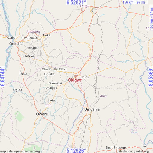
Okigwe GPS coordinates[2]
5° 49' 45.012" North, 7° 21' 2.016" East
| Map corner | latitude | longitude |
|---|---|---|
| Upper-left | 6.52821°, | 6.64744° |
| Center: | 5.82917°, | 7.35056° |
| Lower-right: | 5.12926°, | 8.05369° |
| Map W x H: | 155.5×155.6 km | = 96.6×96.7mi |
| max Lat: | 13.7543° ⇑85.9% North |
| Okigwe: | 5.82917° |
| min Lat: | ⇓14.1% South 4.31231° |
| min Long | Okigwe | max Long |
| 2.73333° | 7.35056° | 14.46552° |
| W 50.5%⇐ | ⇒49.5% E |
Elevation
Elevation of Okigwe is 158 m = 518 ft, and this is 138.5 m = 454 ft below average elevation for this country.
| Max E: |
1599 m = 5246 ft | 68% |
| Avg. | 296.5 m = 973 ft | |
| Okigwe | 158 m = 518 ft | |
Min E: |
2 m = 7 ft | 32% |
See also: Okigwe elevation on elevation.city.
Geographical zone
Okigwe is located in North Torrid zone (between Equator and Tropic of Cancer). Distance of Equator is 648.1 km =402.7 mi to South.| Distance of | km | miles | from Okigwe |
|---|---|---|---|
| North Pole | 9358.9 | 5815.3 | to North |
| Arctic Circle | 6753 | 4196.1 | to North |
| Tropic Cancer | 1957.8 | 1216.5 | to North |
| Equator | 648.1 | 402.7 | to South |


Nearby cities:
15 places around Okigwe: (largest is in red/bold)
• Ajalli
28.6 km =17.8 mi,  326°
326°
• Amaigbo
28.3 km =17.6 mi,  247°
247°
• Awgu
30.5 km =19 mi,  27°
27°
• Dikenafai
22.6 km =14 mi, 253°
• Isiaka
22 km =13.7 mi,  80°
80°
• Isinweke
23.2 km =14.4 mi,  180°
180°
• Mbalano
19.8 km =12.3 mi,  122°
122°
• Ndeaboh
33.2 km =20.6 mi,  46°
46°
• Nkwerre
28.4 km =17.6 mi, 254°
• Nkwoagu Isuochi
18.7 km =11.6 mi,  15°
15°
• Okwe
15.8 km =9.8 mi, 248°
• Uga
32.3 km =20.1 mi,  291°
291°
• Umuelemai
19.7 km =12.2 mi,  217°
217°
• Umunze
19.8 km =12.3 mi,  320°
320°
• Urualla
28 km =17.4 mi,  275°
275°
Sources, notices
• [Note1] Compared only with cities in Nigeria existing in our database
• [Src1] Map data: © OpenStreetMap contributors (CC-BY-SA)
• [Src2] Other city data from geonames.org with taken over terms of usage.
• [Src3] Geographical zone / Annual Mean Temperature by Robert A. Rohde @ Wikipedia
