Ajalli geodata
Ajalli (Anambra) is a seat of a second-order administrative division; located in Nigeria in Africa/Lagos (GMT+1) time zone. In our database, there are 451 cities with bigger population. Compared to other cities in Nigeria, 83.2% of cities are located further ↑North; 52.5% of cities are located further →East and 71.3% of cities have higher elevation than Ajalli. Note1


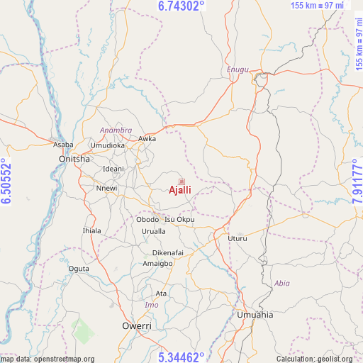
Ajalli GPS coordinates[2]
6° 2' 39.372" North, 7° 12' 31.104" East
| Map corner | latitude | longitude |
|---|---|---|
| Upper-left | 6.74302°, | 6.50552° |
| Center: | 6.04427°, | 7.20864° |
| Lower-right: | 5.34462°, | 7.91177° |
| Map W x H: | 155.5×155.5 km | = 96.6×96.6mi |
| max Lat: | 13.7543° ⇑83.2% North |
| Ajalli: | 6.04427° |
| min Lat: | ⇓16.8% South 4.31231° |
| min Long | Ajalli | max Long |
| 2.73333° | 7.20864° | 14.46552° |
| W 47.5%⇐ | ⇒52.5% E |
Elevation
Elevation of Ajalli is 140 m = 459 ft, and this is 156.5 m = 513 ft below average elevation for this country.
| Max E: |
1599 m = 5246 ft | 71.3% |
| Avg. | 296.5 m = 973 ft | |
| Ajalli | 140 m = 459 ft | |
Min E: |
2 m = 7 ft | 28.7% |
See also: Nigeria elevation on elevation.city.
Geographical zone
Ajalli is located in North Torrid zone (between Equator and Tropic of Cancer). Distance of Equator is 672.1 km =417.6 mi to South.| Distance of | km | miles | from Ajalli |
|---|---|---|---|
| North Pole | 9335 | 5800.5 | to North |
| Arctic Circle | 6729.1 | 4181.3 | to North |
| Tropic Cancer | 1933.9 | 1201.7 | to North |
| Equator | 672.1 | 417.6 | to South |


Nearby cities:
15 places around Ajalli: (largest is in red/bold)
• Abagana
28.8 km =17.9 mi,  304°
304°
• Aguata
13.7 km =8.5 mi,  256°
256°
• Agulu
17.5 km =10.9 mi,  290°
290°
• Awgu
29.9 km =18.6 mi,  83°
83°
• Awka
24.1 km =15 mi,  321°
321°
• Enugu-Ukwu
26.6 km =16.5 mi, 302°
• Igbo-Ukwu
21 km =13 mi, 262°
• Neni
21.2 km =13.2 mi, 285°
• Nkwoagu Isuochi
21.4 km =13.3 mi,  106°
106°
• Oji River
24.5 km =15.2 mi,  16°
16°
• Okigwe
28.6 km =17.8 mi,  146°
146°
• Okwe
29.7 km =18.5 mi,  178°
178°
• Uga
18.7 km =11.6 mi,  229°
229°
• Umunze
9.1 km =5.7 mi,  160°
160°
• Urualla
24.4 km =15.2 mi,  209°
209°
Sources, notices
• [Note1] Compared only with cities in Nigeria existing in our database
• [Src1] Map data: © OpenStreetMap contributors (CC-BY-SA)
• [Src2] Other city data from geonames.org with taken over terms of usage.
• [Src3] Geographical zone / Annual Mean Temperature by Robert A. Rohde @ Wikipedia
