Ogbomoso geodata
Ogbomoso (Oyo) is a seat of a second-order administrative division; located in Nigeria in Africa/Lagos (GMT+1) time zone. In our database, there are 451 cities with bigger population. Compared to other cities in Nigeria, 51.5% of cities are located further ↑North; 89.8% of cities are located further →East and 63.4% of cities have lower elevation than Ogbomoso. Note1


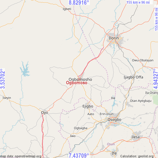
Ogbomoso GPS coordinates[2]
8° 8' 1.428" North, 4° 14' 24.504" East
| Map corner | latitude | longitude |
|---|---|---|
| Upper-left | 8.82916°, | 3.53702° |
| Center: | 8.13373°, | 4.24014° |
| Lower-right: | 7.43709°, | 4.94327° |
| Map W x H: | 154.8×154.8 km | = 96.2×96.2mi |
| max Lat: | 13.7543° ⇑51.5% North |
| Ogbomoso: | 8.13373° |
| min Lat: | ⇓48.5% South 4.31231° |
| min Long | Ogbomoso | max Long |
| 2.73333° | 4.24014° | 14.46552° |
| W 10.2%⇐ | ⇒89.8% E |
Elevation
Elevation of Ogbomoso is 361 m = 1184 ft, and this is 64.5 m = 212 ft above average elevation for this country.
| Max E: |
1599 m = 5246 ft | 36.6% |
| Ogbomoso | 361 m 1184 ft | |
| Avg. | 296.5 m = 973 ft | |
Min E: |
2 m = 7 ft | 63.4% |
See also: Nigeria elevation on elevation.city.
Geographical zone
Ogbomoso is located in North Torrid zone (between Equator and Tropic of Cancer). Distance of Equator is 904.4 km =562 mi to South.| Distance of | km | miles | from Ogbomoso |
|---|---|---|---|
| North Pole | 9102.7 | 5656.2 | to North |
| Arctic Circle | 6496.8 | 4036.9 | to North |
| Tropic Cancer | 1701.5 | 1057.3 | to North |
| Equator | 904.4 | 562 | to South |


Nearby cities:
15 places around Ogbomoso: (largest is in red/bold)
• Afon
37.4 km =23.2 mi,  57°
57°
• Ajaawa
25.8 km =16 mi,  209°
209°
• Awo
44.1 km =27.4 mi,  157°
157°
• Bode Osi
42.6 km =26.5 mi,  181°
181°
• Ede
49.1 km =30.5 mi,  154°
154°
• Ejigbo
26.9 km =16.7 mi, 162°
• Ifon
40 km =24.9 mi,  139°
139°
• Ikoyi-Ile
14.4 km =8.9 mi,  328°
328°
• Ilemona
46.4 km =28.8 mi,  93°
93°
• Ilobu
42.4 km =26.3 mi, 140°
• Ilorin
52.3 km =32.5 mi,  39°
39°
• Inisa
33.2 km =20.6 mi, 161°
• Iresa-Adu
17.6 km =10.9 mi,  107°
107°
• Okuku
49.3 km =30.6 mi, 105°
• Oyo
46.2 km =28.7 mi,  227°
227°
Sources, notices
• [Note1] Compared only with cities in Nigeria existing in our database
• [Src1] Map data: © OpenStreetMap contributors (CC-BY-SA)
• [Src2] Other city data from geonames.org with taken over terms of usage.
• [Src3] Geographical zone / Annual Mean Temperature by Robert A. Rohde @ Wikipedia
