Iresa-Adu geodata
Iresa-Adu (Oyo) is a seat of a second-order administrative division; located in Nigeria in Africa/Lagos (GMT+1) time zone. In our database, there are 451 cities with bigger population. Compared to other cities in Nigeria, 52.3% of cities are located further ↑North; 88.6% of cities are located further →East and 68.3% of cities have lower elevation than Iresa-Adu. Note1


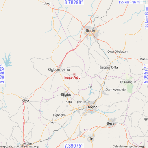
Iresa-Adu GPS coordinates[2]
8° 5' 14.892" North, 4° 23' 33.504" East
| Map corner | latitude | longitude |
|---|---|---|
| Upper-left | 8.78298°, | 3.68952° |
| Center: | 8.08747°, | 4.39264° |
| Lower-right: | 7.39075°, | 5.09577° |
| Map W x H: | 154.8×154.8 km | = 96.2×96.2mi |
| max Lat: | 13.7543° ⇑52.3% North |
| Iresa-Adu: | 8.08747° |
| min Lat: | ⇓47.7% South 4.31231° |
| min Long | Iresa-Adu | max Long |
| 2.73333° | 4.39264° | 14.46552° |
| W 11.4%⇐ | ⇒88.6% E |
Elevation
Elevation of Iresa-Adu is 387 m = 1270 ft, and this is 90.5 m = 297 ft above average elevation for this country.
| Max E: |
1599 m = 5246 ft | 31.7% |
| Iresa-Adu | 387 m 1270 ft | |
| Avg. | 296.5 m = 973 ft | |
Min E: |
2 m = 7 ft | 68.3% |
See also: Nigeria elevation on elevation.city.
Geographical zone
Iresa-Adu is located in North Torrid zone (between Equator and Tropic of Cancer). Distance of Equator is 899.2 km =558.7 mi to South.| Distance of | km | miles | from Iresa-Adu |
|---|---|---|---|
| North Pole | 9107.8 | 5659.3 | to North |
| Arctic Circle | 6501.9 | 4040.1 | to North |
| Tropic Cancer | 1706.7 | 1060.5 | to North |
| Equator | 899.2 | 558.7 | to South |


Nearby cities:
15 places around Iresa-Adu: (largest is in red/bold)
• Afon
29.1 km =18.1 mi,  30°
30°
• Ajaawa
34.1 km =21.2 mi,  239°
239°
• Awo
35.6 km =22.1 mi,  179°
179°
• Ede
39.3 km =24.4 mi,  173°
173°
• Ejigbo
22.3 km =13.9 mi,  202°
202°
• Ifon
26.9 km =16.7 mi,  160°
160°
• Ikirun
35.9 km =22.3 mi,  122°
122°
• Ikoyi-Ile
29.9 km =18.6 mi,  305°
305°
• Ilemona
29.6 km =18.4 mi,  85°
85°
• Ilobu
29.3 km =18.2 mi, 159°
• Inisa
27.2 km =16.9 mi,  193°
193°
• Iragbiji
38.3 km =23.8 mi, 122°
• Offa
36.8 km =22.9 mi,  79°
79°
• Ogbomoso
17.6 km =10.9 mi,  287°
287°
• Okuku
31.8 km =19.8 mi,  104°
104°
Sources, notices
• [Note1] Compared only with cities in Nigeria existing in our database
• [Src1] Map data: © OpenStreetMap contributors (CC-BY-SA)
• [Src2] Other city data from geonames.org with taken over terms of usage.
• [Src3] Geographical zone / Annual Mean Temperature by Robert A. Rohde @ Wikipedia
