Ilorin geodata
Ilorin (Kwara) is a seat of a first-order administrative division; located in Nigeria in Africa/Lagos (GMT+1) time zone. With population of 814,192 people, there are 10 cities with bigger population in this country. Compared to other cities in Nigeria, 50.9% of cities are located further ↓South; 87.1% of cities are located further →East and 56.4% of cities have lower elevation than Ilorin. Note1


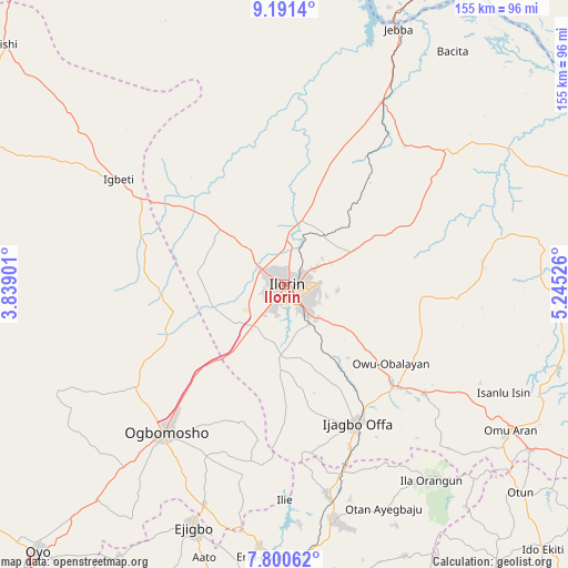
Ilorin GPS coordinates[2]
8° 29' 47.904" North, 4° 32' 31.704" East
| Map corner | latitude | longitude |
|---|---|---|
| Upper-left | 9.1914°, | 3.83901° |
| Center: | 8.49664°, | 4.54214° |
| Lower-right: | 7.80062°, | 5.24526° |
| Map W x H: | 154.6×154.6 km | = 96.1×96.1mi |
| max Lat: | 13.7543° ⇑49.1% North |
| Ilorin: | 8.49664° |
| min Lat: | ⇓50.9% South 4.31231° |
| min Long | Ilorin | max Long |
| 2.73333° | 4.54214° | 14.46552° |
| W 12.9%⇐ | ⇒87.1% E |
Elevation
Elevation of Ilorin is 320 m = 1050 ft, and this is 23.5 m = 77 ft above average elevation for this country.
| Max E: |
1599 m = 5246 ft | 43.6% |
| Ilorin | 320 m 1050 ft | |
| Avg. | 296.5 m = 973 ft | |
Min E: |
2 m = 7 ft | 56.4% |
See also: Ilorin elevation on elevation.city.
Geographical zone
Ilorin is located in North Torrid zone (between Equator and Tropic of Cancer). Distance of Equator is 944.7 km =587 mi to South.| Distance of | km | miles | from Ilorin |
|---|---|---|---|
| North Pole | 9062.3 | 5631.1 | to North |
| Arctic Circle | 6456.4 | 4011.8 | to North |
| Tropic Cancer | 1661.2 | 1032.2 | to North |
| Equator | 944.7 | 587 | to South |


Nearby cities:
15 places around Ilorin: (largest is in red/bold)
• Afon
20.5 km =12.7 mi,  184°
184°
• Ajasse Ipo
42.1 km =26.2 mi,  134°
134°
• Alapa
22 km =13.7 mi,  307°
307°
• Bode Saadu
55.8 km =34.7 mi,  28°
28°
• Fufu
20.4 km =12.7 mi,  105°
105°
• Igbeti
53.2 km =33.1 mi,  301°
301°
• Ikoyi-Ile
49.5 km =30.8 mi,  235°
235°
• Ilemona
44.9 km =27.9 mi,  163°
163°
• Iresa-Adu
48.4 km =30.1 mi,  199°
199°
• Offa
43.4 km =27 mi,  153°
153°
• Ogbomoso
52.3 km =32.5 mi,  219°
219°
• Oke-Oyi
21.4 km =13.3 mi,  63°
63°
• Okuku
55.1 km =34.2 mi, 164°
• Owu-Isin
57.7 km =35.9 mi, 114°
• Oyan
55.5 km =34.5 mi, 153°
Sources, notices
• [Note1] Compared only with cities in Nigeria existing in our database
• [Src1] Map data: © OpenStreetMap contributors (CC-BY-SA)
• [Src2] Other city data from geonames.org with taken over terms of usage.
• [Src3] Geographical zone / Annual Mean Temperature by Robert A. Rohde @ Wikipedia
