Inisa geodata
Inisa (Osun) is a populated place; located in Nigeria in Africa/Lagos (GMT+1) time zone. With population of 164,161 people, there are 53 cities with bigger population in this country. Compared to other cities in Nigeria, 55.1% of cities are located further ↑North; 89.3% of cities are located further →East and 65.1% of cities have lower elevation than Inisa. Note1


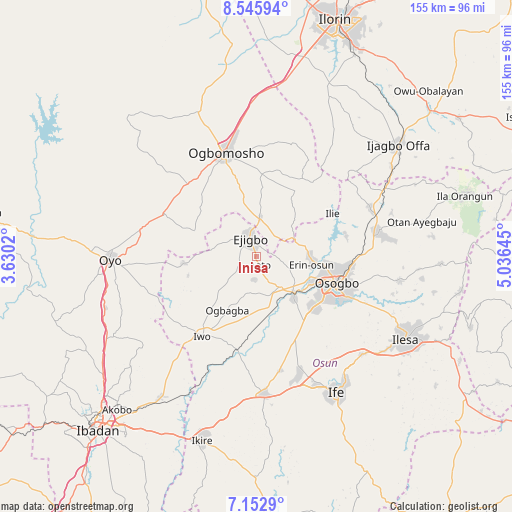
Inisa GPS coordinates[2]
7° 51' 0" North, 4° 19' 59.988" East
| Map corner | latitude | longitude |
|---|---|---|
| Upper-left | 8.54594°, | 3.6302° |
| Center: | 7.85°, | 4.33333° |
| Lower-right: | 7.1529°, | 5.03645° |
| Map W x H: | 154.9×154.9 km | = 96.3×96.3mi |
| max Lat: | 13.7543° ⇑55.1% North |
| Inisa: | 7.85° |
| min Lat: | ⇓44.9% South 4.31231° |
| min Long | Inisa | max Long |
| 2.73333° | 4.33333° | 14.46552° |
| W 10.7%⇐ | ⇒89.3% E |
Elevation
Elevation of Inisa is 368 m = 1207 ft, and this is 71.5 m = 235 ft above average elevation for this country.
| Max E: |
1599 m = 5246 ft | 34.9% |
| Inisa | 368 m 1207 ft | |
| Avg. | 296.5 m = 973 ft | |
Min E: |
2 m = 7 ft | 65.1% |
See also: Inisa elevation on elevation.city.
Geographical zone
Inisa is located in North Torrid zone (between Equator and Tropic of Cancer). Distance of Equator is 872.8 km =542.3 mi to South.| Distance of | km | miles | from Inisa |
|---|---|---|---|
| North Pole | 9134.2 | 5675.7 | to North |
| Arctic Circle | 6528.3 | 4056.5 | to North |
| Tropic Cancer | 1733.1 | 1076.9 | to North |
| Equator | 872.8 | 542.3 | to South |


Nearby cities:
15 places around Inisa: (largest is in red/bold)
• Ajaawa
24.5 km =15.2 mi,  291°
291°
• Awo
11.4 km =7.1 mi,  143°
143°
• Bode Osi
15.8 km =9.8 mi,  226°
226°
• Ede
16.9 km =10.5 mi, 138°
• Ejigbo
6.3 km =3.9 mi,  340°
340°
• Ifon
15.8 km =9.8 mi,  85°
85°
• Ikirun
37.5 km =23.3 mi,  79°
79°
• Ile-Ogbo
27.2 km =16.9 mi,  200°
200°
• Ilobu
16.8 km =10.4 mi, 93°
• Ipetumodu
38.5 km =23.9 mi,  161°
161°
• Iresa-Adu
27.2 km =16.9 mi,  13°
13°
• Iwo
29.1 km =18.1 mi,  215°
215°
• Ogbomoso
33.2 km =20.6 mi, 341°
• Olupona
32.3 km =20.1 mi,  210°
210°
• Osogbo
26.2 km =16.3 mi,  109°
109°
Sources, notices
• [Note1] Compared only with cities in Nigeria existing in our database
• [Src1] Map data: © OpenStreetMap contributors (CC-BY-SA)
• [Src2] Other city data from geonames.org with taken over terms of usage.
• [Src3] Geographical zone / Annual Mean Temperature by Robert A. Rohde @ Wikipedia
