Ilemona geodata
Ilemona (Kwara) is a seat of a second-order administrative division; located in Nigeria in Africa/Lagos (GMT+1) time zone. In our database, there are 451 cities with bigger population. Compared to other cities in Nigeria, 51.7% of cities are located further ↑North; 86% of cities are located further →East and 71.6% of cities have lower elevation than Ilemona. Note1


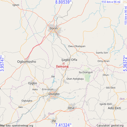
Ilemona GPS coordinates[2]
8° 6' 35.712" North, 4° 39' 38.124" East
| Map corner | latitude | longitude |
|---|---|---|
| Upper-left | 8.80539°, | 3.95747° |
| Center: | 8.10992°, | 4.66059° |
| Lower-right: | 7.41324°, | 5.36372° |
| Map W x H: | 154.8×154.8 km | = 96.2×96.2mi |
| max Lat: | 13.7543° ⇑51.7% North |
| Ilemona: | 8.10992° |
| min Lat: | ⇓48.3% South 4.31231° |
| min Long | Ilemona | max Long |
| 2.73333° | 4.66059° | 14.46552° |
| W 14%⇐ | ⇒86% E |
Elevation
Elevation of Ilemona is 411 m = 1348 ft, and this is 114.5 m = 376 ft above average elevation for this country.
| Max E: |
1599 m = 5246 ft | 28.4% |
| Ilemona | 411 m 1348 ft | |
| Avg. | 296.5 m = 973 ft | |
Min E: |
2 m = 7 ft | 71.6% |
See also: Nigeria elevation on elevation.city.
Geographical zone
Ilemona is located in North Torrid zone (between Equator and Tropic of Cancer). Distance of Equator is 901.7 km =560.3 mi to South.| Distance of | km | miles | from Ilemona |
|---|---|---|---|
| North Pole | 9105.3 | 5657.8 | to North |
| Arctic Circle | 6499.4 | 4038.5 | to North |
| Tropic Cancer | 1704.2 | 1058.9 | to North |
| Equator | 901.7 | 560.3 | to South |


Nearby cities:
15 places around Ilemona: (largest is in red/bold)
• Afon
26.9 km =16.7 mi,  327°
327°
• Ajasse Ipo
22 km =13.7 mi,  51°
51°
• Fufu
38.2 km =23.7 mi,  9°
9°
• Ibokun
36.7 km =22.8 mi,  168°
168°
• Ifon
34.4 km =21.4 mi,  216°
216°
• Ikirun
21.9 km =13.6 mi,  178°
178°
• Ila Orangun
28.7 km =17.8 mi,  111°
111°
• Ilobu
35.6 km =22.1 mi,  212°
212°
• Iragbiji
23.1 km =14.4 mi, 172°
• Iresa-Adu
29.6 km =18.4 mi,  265°
265°
• Offa
7.9 km =4.9 mi,  56°
56°
• Okuku
10.3 km =6.4 mi, 172°
• Osogbo
39.4 km =24.5 mi,  196°
196°
• Otan Ayegbaju
22.9 km =14.2 mi,  142°
142°
• Oyan
13.4 km =8.3 mi,  119°
119°
Sources, notices
• [Note1] Compared only with cities in Nigeria existing in our database
• [Src1] Map data: © OpenStreetMap contributors (CC-BY-SA)
• [Src2] Other city data from geonames.org with taken over terms of usage.
• [Src3] Geographical zone / Annual Mean Temperature by Robert A. Rohde @ Wikipedia
