Nafada geodata
Nafada (Gombe) is a seat of a second-order administrative division; located in Nigeria in Africa/Lagos (GMT+1) time zone. With population of 22,920 people, there are 184 cities with bigger population in this country. Compared to other cities in Nigeria, 73.1% of cities are located further ↓South; 91% of cities are located further ←West and 51% of cities have higher elevation than Nafada. Note1


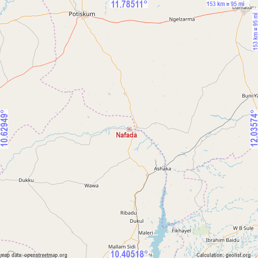
Nafada GPS coordinates[2]
11° 5' 45.456" North, 11° 19' 57.396" East
| Map corner | latitude | longitude |
|---|---|---|
| Upper-left | 11.78511°, | 10.62949° |
| Center: | 11.09596°, | 11.33261° |
| Lower-right: | 10.40518°, | 12.03574° |
| Map W x H: | 153.4×153.4 km | = 95.3×95.3mi |
| max Lat: | 13.7543° ⇑26.9% North |
| Nafada: | 11.09596° |
| min Lat: | ⇓73.1% South 4.31231° |
| min Long | Nafada | max Long |
| 2.73333° | 11.33261° | 14.46552° |
| W 91%⇐ | ⇒9% E |
Elevation
Elevation of Nafada is 275 m = 902 ft, and this is 21.5 m = 71 ft below average elevation for this country.
| Max E: |
1599 m = 5246 ft | 51% |
| Avg. | 296.5 m = 973 ft | |
| Nafada | 275 m = 902 ft | |
Min E: |
2 m = 7 ft | 49% |
See also: Nigeria elevation on elevation.city.
Geographical zone
Nafada is located in North Torrid zone (between Equator and Tropic of Cancer). Distance of Equator is 1233.8 km =766.6 mi to South.| Distance of | km | miles | from Nafada |
|---|---|---|---|
| North Pole | 8773.3 | 5451.5 | to North |
| Arctic Circle | 6167.4 | 3832.2 | to North |
| Tropic Cancer | 1372.2 | 852.6 | to North |
| Equator | 1233.8 | 766.6 | to South |


Nearby cities:
15 places around Nafada: (largest is in red/bold)
• Bajoga
29.3 km =18.2 mi,  158°
158°
• Bara
42.1 km =26.2 mi,  114°
114°
• Buni Yadi
76.3 km =47.4 mi,  74°
74°
• Damagum
64.7 km =40.2 mi,  0°
0°
• Daura
51.6 km =32.1 mi,  8°
8°
• Dukku
68.3 km =42.4 mi,  243°
243°
• Fika
21.4 km =13.3 mi,  352°
352°
• Gujba
79.5 km =49.4 mi,  55°
55°
• Kafarati
83.4 km =51.8 mi,  198°
198°
• Kari
85.8 km =53.3 mi,  281°
281°
• Kwaya Kusar
86.4 km =53.7 mi,  139°
139°
• Mallam Sidi
69.9 km =43.4 mi,  183°
183°
• Potiskum
74 km =46 mi,  338°
338°
• Sade
77.7 km =48.3 mi,  292°
292°
• Yanda Bayo
78.6 km =48.8 mi,  305°
305°
Sources, notices
• [Note1] Compared only with cities in Nigeria existing in our database
• [Src1] Map data: © OpenStreetMap contributors (CC-BY-SA)
• [Src2] Other city data from geonames.org with taken over terms of usage.
• [Src3] Geographical zone / Annual Mean Temperature by Robert A. Rohde @ Wikipedia
