Daura geodata
Daura (Yobe) is a populated place; located in Nigeria in Africa/Lagos (GMT+1) time zone. With population of 78,277 people, there are 116 cities with bigger population in this country. Compared to other cities in Nigeria, 78.7% of cities are located further ↓South; 91.6% of cities are located further ←West and 81.8% of cities have lower elevation than Daura. Note1


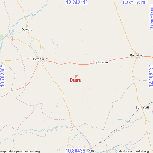
Daura GPS coordinates[2]
11° 33' 14.76" North, 11° 24' 21.6" East
| Map corner | latitude | longitude |
|---|---|---|
| Upper-left | 12.24211°, | 10.70288° |
| Center: | 11.5541°, | 11.406° |
| Lower-right: | 10.86439°, | 12.10913° |
| Map W x H: | 153.2×153.2 km | = 95.2×95.2mi |
| max Lat: | 13.7543° ⇑21.3% North |
| Daura: | 11.5541° |
| min Lat: | ⇓78.7% South 4.31231° |
| min Long | Daura | max Long |
| 2.73333° | 11.406° | 14.46552° |
| W 91.6%⇐ | ⇒8.4% E |
Elevation
Elevation of Daura is 484 m = 1588 ft, and this is 187.5 m = 615 ft above average elevation for this country.
| Max E: |
1599 m = 5246 ft | 18.2% |
| Daura | 484 m 1588 ft | |
| Avg. | 296.5 m = 973 ft | |
Min E: |
2 m = 7 ft | 81.8% |
See also: Daura elevation on elevation.city.
Geographical zone
Daura is located in North Torrid zone (between Equator and Tropic of Cancer). Distance of Equator is 1284.7 km =798.3 mi to South.| Distance of | km | miles | from Daura |
|---|---|---|---|
| North Pole | 8722.4 | 5419.8 | to North |
| Arctic Circle | 6116.5 | 3800.6 | to North |
| Tropic Cancer | 1321.2 | 821 | to North |
| Equator | 1284.7 | 798.3 | to South |


Nearby cities:
15 places around Daura: (largest is in red/bold)
• Babban Gida
77.7 km =48.3 mi,  30°
30°
• Bajoga
78.2 km =48.6 mi,  177°
177°
• Bara
75 km =46.6 mi,  156°
156°
• Buni Yadi
72.7 km =45.2 mi,  115°
115°
• Damagum
15.8 km =9.8 mi,  330°
330°
• Damaturu
64.1 km =39.8 mi,  70°
70°
• Dambam
77.3 km =48 mi,  280°
280°
• Fika
31.6 km =19.6 mi,  199°
199°
• Gujba
57.8 km =35.9 mi,  96°
96°
• Lajere
47.5 km =29.5 mi,  4°
4°
• Nafada
51.6 km =32.1 mi,  188°
188°
• Potiskum
39.6 km =24.6 mi,  296°
296°
• Sabon Garin Nangere
48.9 km =30.4 mi,  312°
312°
• Sade
82.7 km =51.4 mi,  254°
254°
• Yanda Bayo
72.1 km =44.8 mi,  265°
265°
Sources, notices
• [Note1] Compared only with cities in Nigeria existing in our database
• [Src1] Map data: © OpenStreetMap contributors (CC-BY-SA)
• [Src2] Other city data from geonames.org with taken over terms of usage.
• [Src3] Geographical zone / Annual Mean Temperature by Robert A. Rohde @ Wikipedia
