Potiskum geodata
Potiskum (Yobe) is a seat of a second-order administrative division; located in Nigeria in Africa/Lagos (GMT+1) time zone. With population of 86,002 people, there are 101 cities with bigger population in this country. Compared to other cities in Nigeria, 80.7% of cities are located further ↓South; 89.4% of cities are located further ←West and 74.7% of cities have lower elevation than Potiskum. Note1


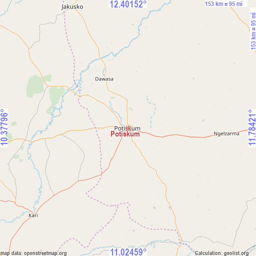
Potiskum GPS coordinates[2]
11° 42' 50.076" North, 11° 4' 51.888" East
| Map corner | latitude | longitude |
|---|---|---|
| Upper-left | 12.40152°, | 10.37796° |
| Center: | 11.71391°, | 11.08108° |
| Lower-right: | 11.02459°, | 11.78421° |
| Map W x H: | 153.1×153.1 km | = 95.1×95.1mi |
| max Lat: | 13.7543° ⇑19.3% North |
| Potiskum: | 11.71391° |
| min Lat: | ⇓80.7% South 4.31231° |
| min Long | Potiskum | max Long |
| 2.73333° | 11.08108° | 14.46552° |
| W 89.4%⇐ | ⇒10.6% E |
Elevation
Elevation of Potiskum is 427 m = 1401 ft, and this is 130.5 m = 428 ft above average elevation for this country.
| Max E: |
1599 m = 5246 ft | 25.3% |
| Potiskum | 427 m 1401 ft | |
| Avg. | 296.5 m = 973 ft | |
Min E: |
2 m = 7 ft | 74.7% |
See also: Potiskum elevation on elevation.city.
Geographical zone
Potiskum is located in North Torrid zone (between Equator and Tropic of Cancer). Distance of Equator is 1302.5 km =809.3 mi to South.| Distance of | km | miles | from Potiskum |
|---|---|---|---|
| North Pole | 8704.6 | 5408.8 | to North |
| Arctic Circle | 6098.7 | 3789.6 | to North |
| Tropic Cancer | 1303.5 | 810 | to North |
| Equator | 1302.5 | 809.3 | to South |


Nearby cities:
15 places around Potiskum: (largest is in red/bold)
• Damagum
27.9 km =17.3 mi,  98°
98°
• Dambam
40.8 km =25.4 mi,  264°
264°
• Daura
39.6 km =24.6 mi,  116°
116°
• Fika
53.5 km =33.2 mi,  152°
152°
• Gamawa
75.3 km =46.8 mi,  308°
308°
• Jakusko
80.3 km =49.9 mi,  335°
335°
• Kari
76.8 km =47.7 mi,  227°
227°
• Lajere
49 km =30.4 mi,  52°
52°
• Madara
69.3 km =43.1 mi,  276°
276°
• Misau
80.4 km =50 mi,  236°
236°
• Nafada
74 km =46 mi,  158°
158°
• Sabon Garin Nangere
15.1 km =9.4 mi,  356°
356°
• Sade
59.4 km =36.9 mi, 228°
• Yanda Bayo
43.1 km =26.8 mi, 237°
• Zadawa
83.1 km =51.6 mi,  249°
249°
Sources, notices
• [Note1] Compared only with cities in Nigeria existing in our database
• [Src1] Map data: © OpenStreetMap contributors (CC-BY-SA)
• [Src2] Other city data from geonames.org with taken over terms of usage.
• [Src3] Geographical zone / Annual Mean Temperature by Robert A. Rohde @ Wikipedia
