Dukku geodata
Dukku (Gombe) is a seat of a second-order administrative division; located in Nigeria in Africa/Lagos (GMT+1) time zone. With population of 16,961 people, there are 219 cities with bigger population in this country. Compared to other cities in Nigeria, 71.2% of cities are located further ↓South; 88.3% of cities are located further ←West and 80.4% of cities have lower elevation than Dukku. Note1


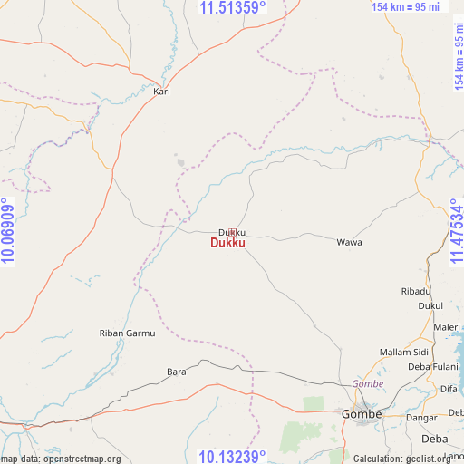
Dukku GPS coordinates[2]
10° 49' 25.644" North, 10° 46' 19.956" East
| Map corner | latitude | longitude |
|---|---|---|
| Upper-left | 11.51359°, | 10.06909° |
| Center: | 10.82379°, | 10.77221° |
| Lower-right: | 10.13239°, | 11.47534° |
| Map W x H: | 153.6×153.6 km | = 95.4×95.4mi |
| max Lat: | 13.7543° ⇑28.8% North |
| Dukku: | 10.82379° |
| min Lat: | ⇓71.2% South 4.31231° |
| min Long | Dukku | max Long |
| 2.73333° | 10.77221° | 14.46552° |
| W 88.3%⇐ | ⇒11.7% E |
Elevation
Elevation of Dukku is 474 m = 1555 ft, and this is 177.5 m = 582 ft above average elevation for this country.
| Max E: |
1599 m = 5246 ft | 19.6% |
| Dukku | 474 m 1555 ft | |
| Avg. | 296.5 m = 973 ft | |
Min E: |
2 m = 7 ft | 80.4% |
See also: Nigeria elevation on elevation.city.
Geographical zone
Dukku is located in North Torrid zone (between Equator and Tropic of Cancer). Distance of Equator is 1203.5 km =747.8 mi to South.| Distance of | km | miles | from Dukku |
|---|---|---|---|
| North Pole | 8803.6 | 5470.3 | to North |
| Arctic Circle | 6197.7 | 3851.1 | to North |
| Tropic Cancer | 1402.4 | 871.4 | to North |
| Equator | 1203.5 | 747.8 | to South |


Nearby cities:
15 places around Dukku: (largest is in red/bold)
• Akko
63.4 km =39.4 mi,  159°
159°
• Bajoga
72.1 km =44.8 mi,  87°
87°
• Bara
50.2 km =31.2 mi,  185°
185°
• Darazo
44 km =27.3 mi,  296°
296°
• Gabarin
47.9 km =29.8 mi,  311°
311°
• Gombe
73.4 km =45.6 mi,  143°
143°
• Kafarati
60.4 km =37.5 mi, 144°
• Kari
52.4 km =32.6 mi,  333°
333°
• Kirfi
61.5 km =38.2 mi,  220°
220°
• Mallam Sidi
69.3 km =43.1 mi,  124°
124°
• Misau
63.9 km =39.7 mi, 328°
• Nafada
68.3 km =42.4 mi,  63°
63°
• Sade
60.5 km =37.6 mi,  349°
349°
• Yanda Bayo
76 km =47.2 mi,  357°
357°
• Zalanga
69.1 km =42.9 mi,  250°
250°
Sources, notices
• [Note1] Compared only with cities in Nigeria existing in our database
• [Src1] Map data: © OpenStreetMap contributors (CC-BY-SA)
• [Src2] Other city data from geonames.org with taken over terms of usage.
• [Src3] Geographical zone / Annual Mean Temperature by Robert A. Rohde @ Wikipedia
