Machina geodata
Machina (Yobe) is a seat of a second-order administrative division; located in Nigeria in Africa/Lagos (GMT+1) time zone. With population of 11,707 people, there are 301 cities with bigger population in this country. Compared to other cities in Nigeria, 98.3% of cities are located further ↓South; 85.1% of cities are located further ←West and 64.5% of cities have lower elevation than Machina. Note1


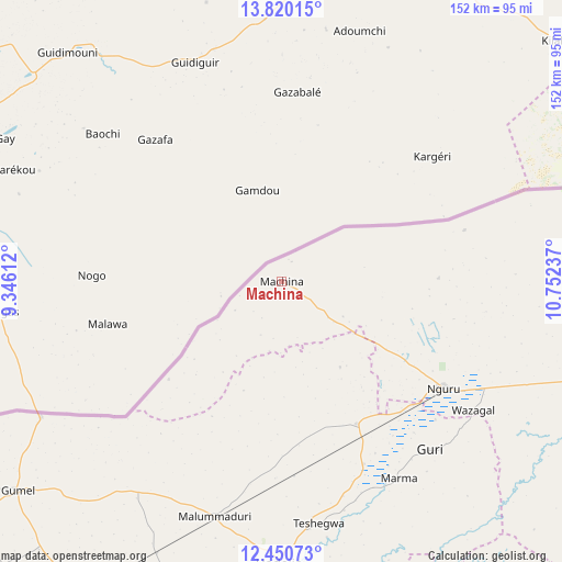
Machina GPS coordinates[2]
13° 8' 11.004" North, 10° 2' 57.264" East
| Map corner | latitude | longitude |
|---|---|---|
| Upper-left | 13.82015°, | 9.34612° |
| Center: | 13.13639°, | 10.04924° |
| Lower-right: | 12.45073°, | 10.75237° |
| Map W x H: | 152.3×152.3 km | = 94.6×94.6mi |
| max Lat: | 13.7543° ⇑1.7% North |
| Machina: | 13.13639° |
| min Lat: | ⇓98.3% South 4.31231° |
| min Long | Machina | max Long |
| 2.73333° | 10.04924° | 14.46552° |
| W 85.1%⇐ | ⇒14.9% E |
Elevation
Elevation of Machina is 366 m = 1201 ft, and this is 69.5 m = 228 ft above average elevation for this country.
| Max E: |
1599 m = 5246 ft | 35.5% |
| Machina | 366 m 1201 ft | |
| Avg. | 296.5 m = 973 ft | |
Min E: |
2 m = 7 ft | 64.5% |
See also: Nigeria elevation on elevation.city.
Geographical zone
Machina is located in North Torrid zone (between Equator and Tropic of Cancer). Distance of this Northern Tropic circle is 1145.3 km =711.7 mi to North.| Distance of | km | miles | from Machina |
|---|---|---|---|
| North Pole | 8546.4 | 5310.5 | to North |
| Arctic Circle | 5940.5 | 3691.3 | to North |
| Tropic Cancer | 1145.3 | 711.7 | to North |
| Equator | 1460.6 | 907.6 | to South |


Nearby cities:
15 places around Machina: (largest is in red/bold)
• Auyo
90.1 km =56 mi,  187°
187°
• Birniwa
43.4 km =27 mi,  152°
152°
• Gagarawa
98.7 km =61.3 mi,  214°
214°
• Gorgoram
90 km =55.9 mi,  127°
127°
• Gumel
91.4 km =56.8 mi,  231°
231°
• Guri
60.6 km =37.7 mi,  138°
138°
• Hadejia
75.9 km =47.2 mi,  180°
180°
• Jajimaji
86.2 km =53.6 mi,  107°
107°
• Kaugama
81 km =50.3 mi,  204°
204°
• Kiri Kasamma
54.1 km =33.6 mi,  155°
155°
• Kumagunnam
63.4 km =39.4 mi,  88°
88°
• Maigatari
75 km =46.6 mi,  240°
240°
• Malam Madori
66.1 km =41.1 mi, 196°
• Mallammaduri
64.4 km =40 mi, 188°
• Nguru
52.6 km =32.7 mi,  123°
123°
Sources, notices
• [Note1] Compared only with cities in Nigeria existing in our database
• [Src1] Map data: © OpenStreetMap contributors (CC-BY-SA)
• [Src2] Other city data from geonames.org with taken over terms of usage.
• [Src3] Geographical zone / Annual Mean Temperature by Robert A. Rohde @ Wikipedia
