Guri geodata
Guri (Jigawa) is a seat of a second-order administrative division; located in Nigeria in Africa/Lagos (GMT+1) time zone. In our database, there are 451 cities with bigger population. Compared to other cities in Nigeria, 93.9% of cities are located further ↓South; 86.6% of cities are located further ←West and 61.8% of cities have lower elevation than Guri. Note1


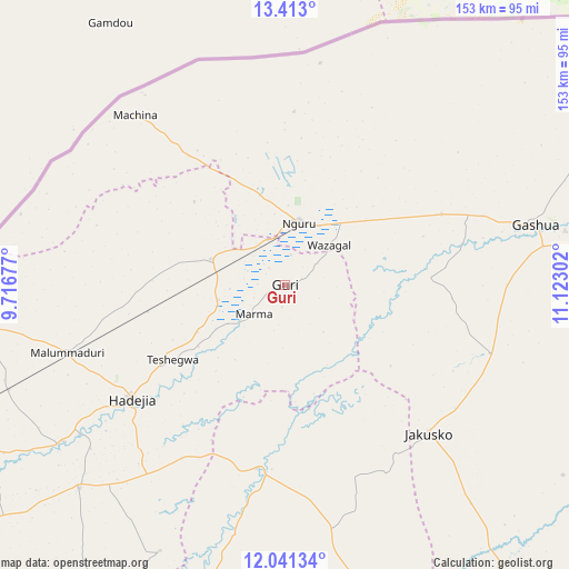
Guri GPS coordinates[2]
12° 43' 41.16" North, 10° 25' 11.604" East
| Map corner | latitude | longitude |
|---|---|---|
| Upper-left | 13.413°, | 9.71677° |
| Center: | 12.7281°, | 10.41989° |
| Lower-right: | 12.04134°, | 11.12302° |
| Map W x H: | 152.5×152.5 km | = 94.8×94.8mi |
| max Lat: | 13.7543° ⇑6.1% North |
| Guri: | 12.7281° |
| min Lat: | ⇓93.9% South 4.31231° |
| min Long | Guri | max Long |
| 2.73333° | 10.41989° | 14.46552° |
| W 86.6%⇐ | ⇒13.4% E |
Elevation
Elevation of Guri is 354 m = 1161 ft, and this is 57.5 m = 189 ft above average elevation for this country.
| Max E: |
1599 m = 5246 ft | 38.2% |
| Guri | 354 m 1161 ft | |
| Avg. | 296.5 m = 973 ft | |
Min E: |
2 m = 7 ft | 61.8% |
See also: Nigeria elevation on elevation.city.
Geographical zone
Guri is located in North Torrid zone (between Equator and Tropic of Cancer). Distance of this Northern Tropic circle is 1190.7 km =739.9 mi to North.| Distance of | km | miles | from Guri |
|---|---|---|---|
| North Pole | 8591.8 | 5338.7 | to North |
| Arctic Circle | 5985.9 | 3719.5 | to North |
| Tropic Cancer | 1190.7 | 739.9 | to North |
| Equator | 1415.2 | 879.4 | to South |


Nearby cities:
15 places around Guri: (largest is in red/bold)
• Auyo
68.2 km =42.4 mi,  229°
229°
• Birniwa
21.1 km =13.1 mi,  289°
289°
• Gamawa
67.3 km =41.8 mi,  169°
169°
• Gashua
69.2 km =43 mi,  76°
76°
• Gorgoram
32.4 km =20.1 mi,  107°
107°
• Hadejia
51.2 km =31.8 mi, 233°
• Jajimaji
46 km =28.6 mi,  65°
65°
• Jakusko
55.2 km =34.3 mi,  135°
135°
• Katagum
49.8 km =30.9 mi,  188°
188°
• Kiri Kasamma
18.4 km =11.4 mi,  257°
257°
• Kumagunnam
52.9 km =32.9 mi,  26°
26°
• Machina
60.6 km =37.7 mi,  318°
318°
• Malam Madori
61.2 km =38 mi,  252°
252°
• Mallammaduri
53.4 km =33.2 mi, 250°
• Nguru
17 km =10.6 mi,  13°
13°
Sources, notices
• [Note1] Compared only with cities in Nigeria existing in our database
• [Src1] Map data: © OpenStreetMap contributors (CC-BY-SA)
• [Src2] Other city data from geonames.org with taken over terms of usage.
• [Src3] Geographical zone / Annual Mean Temperature by Robert A. Rohde @ Wikipedia
