Gagarawa geodata
Gagarawa (Jigawa) is a seat of a second-order administrative division; located in Nigeria in Africa/Lagos (GMT+1) time zone. With population of 11,450 people, there are 314 cities with bigger population in this country. Compared to other cities in Nigeria, 89.4% of cities are located further ↓South; 80.4% of cities are located further ←West and 65.9% of cities have lower elevation than Gagarawa. Note1


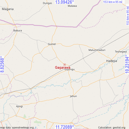
Gagarawa GPS coordinates[2]
12° 24' 30.528" North, 9° 31' 43.716" East
| Map corner | latitude | longitude |
|---|---|---|
| Upper-left | 13.09426°, | 8.82568° |
| Center: | 12.40848°, | 9.52881° |
| Lower-right: | 11.72089°, | 10.23194° |
| Map W x H: | 152.7×152.7 km | = 94.9×94.9mi |
| max Lat: | 13.7543° ⇑10.6% North |
| Gagarawa: | 12.40848° |
| min Lat: | ⇓89.4% South 4.31231° |
| min Long | Gagarawa | max Long |
| 2.73333° | 9.52881° | 14.46552° |
| W 80.4%⇐ | ⇒19.6% E |
Elevation
Elevation of Gagarawa is 374 m = 1227 ft, and this is 77.5 m = 254 ft above average elevation for this country.
| Max E: |
1599 m = 5246 ft | 34.1% |
| Gagarawa | 374 m 1227 ft | |
| Avg. | 296.5 m = 973 ft | |
Min E: |
2 m = 7 ft | 65.9% |
See also: Nigeria elevation on elevation.city.
Geographical zone
Gagarawa is located in North Torrid zone (between Equator and Tropic of Cancer). Distance of this Northern Tropic circle is 1226.2 km =761.9 mi to North.| Distance of | km | miles | from Gagarawa |
|---|---|---|---|
| North Pole | 8627.4 | 5360.8 | to North |
| Arctic Circle | 6021.5 | 3741.6 | to North |
| Tropic Cancer | 1226.2 | 761.9 | to North |
| Equator | 1379.7 | 857.3 | to South |


Nearby cities:
15 places around Gagarawa: (largest is in red/bold)
• Auyo
45.3 km =28.1 mi,  100°
100°
• Babura
68.9 km =42.8 mi,  305°
305°
• Garki
36.9 km =22.9 mi,  274°
274°
• Gumel
28.7 km =17.8 mi,  327°
327°
• Hadejia
55.9 km =34.7 mi,  84°
84°
• Jahun
38.5 km =23.9 mi,  163°
163°
• Kafin Hausa
45.6 km =28.3 mi,  114°
114°
• Kaugama
23.7 km =14.7 mi,  72°
72°
• Maigatari
45.3 km =28.1 mi,  348°
348°
• Malam Madori
42 km =26.1 mi, 65°
• Mallammaduri
49.6 km =30.8 mi, 69°
• Miga
27.5 km =17.1 mi,  133°
133°
• Ringim
49 km =30.4 mi,  234°
234°
• Sule Tankarkar
43.5 km =27 mi, 311°
• Taura
33.5 km =20.8 mi, 232°
Sources, notices
• [Note1] Compared only with cities in Nigeria existing in our database
• [Src1] Map data: © OpenStreetMap contributors (CC-BY-SA)
• [Src2] Other city data from geonames.org with taken over terms of usage.
• [Src3] Geographical zone / Annual Mean Temperature by Robert A. Rohde @ Wikipedia
