Lalupon geodata
Lalupon (Oyo) is a populated place; located in Nigeria in Africa/Lagos (GMT+1) time zone. With population of 81,130 people, there are 109 cities with bigger population in this country. Compared to other cities in Nigeria, 62.3% of cities are located further ↑North; 91.5% of cities are located further →East and 57.7% of cities have higher elevation than Lalupon. Note1


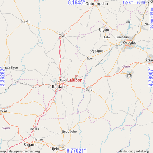
Lalupon GPS coordinates[2]
7° 28' 4.476" North, 4° 3' 57.384" East
| Map corner | latitude | longitude |
|---|---|---|
| Upper-left | 8.1645°, | 3.36282° |
| Center: | 7.46791°, | 4.06594° |
| Lower-right: | 6.77021°, | 4.76907° |
| Map W x H: | 155×155 km | = 96.3×96.3mi |
| max Lat: | 13.7543° ⇑62.3% North |
| Lalupon: | 7.46791° |
| min Lat: | ⇓37.7% South 4.31231° |
| min Long | Lalupon | max Long |
| 2.73333° | 4.06594° | 14.46552° |
| W 8.5%⇐ | ⇒91.5% E |
Elevation
Elevation of Lalupon is 226 m = 741 ft, and this is 70.5 m = 231 ft below average elevation for this country.
| Max E: |
1599 m = 5246 ft | 57.7% |
| Avg. | 296.5 m = 973 ft | |
| Lalupon | 226 m = 741 ft | |
Min E: |
2 m = 7 ft | 42.3% |
See also: Lalupon elevation on elevation.city.
Geographical zone
Lalupon is located in North Torrid zone (between Equator and Tropic of Cancer). Distance of Equator is 830.4 km =516 mi to South.| Distance of | km | miles | from Lalupon |
|---|---|---|---|
| North Pole | 9176.7 | 5702.1 | to North |
| Arctic Circle | 6570.8 | 4082.9 | to North |
| Tropic Cancer | 1775.6 | 1103.3 | to North |
| Equator | 830.4 | 516 | to South |


Nearby cities:
15 places around Lalupon: (largest is in red/bold)
• Akanran
21.3 km =13.2 mi,  192°
192°
• Apomu
18.3 km =11.4 mi,  134°
134°
• Egbeda
10.2 km =6.3 mi, 190°
• Fiditi
31.9 km =19.8 mi,  329°
329°
• Gbongan
31.7 km =19.7 mi,  88°
88°
• Ibadan
20.3 km =12.6 mi,  240°
240°
• Idi-Ayunre
34.5 km =21.4 mi,  220°
220°
• Ido
34 km =21.1 mi,  270°
270°
• Ikire
17.2 km =10.7 mi, 129°
• Ile-Ogbo
26.1 km =16.2 mi,  49°
49°
• Iwo
22.6 km =14 mi,  34°
34°
• Iyana-Ofa
3.8 km =2.4 mi, 25°
• Modakeke
23.4 km =14.5 mi,  113°
113°
• Moniya
18.3 km =11.4 mi,  291°
291°
• Olupona
19.6 km =12.2 mi,  41°
41°
Sources, notices
• [Note1] Compared only with cities in Nigeria existing in our database
• [Src1] Map data: © OpenStreetMap contributors (CC-BY-SA)
• [Src2] Other city data from geonames.org with taken over terms of usage.
• [Src3] Geographical zone / Annual Mean Temperature by Robert A. Rohde @ Wikipedia
