Ibadan geodata
Ibadan (Oyo) is a seat of a first-order administrative division; located in Nigeria in Africa/Lagos (GMT+1) time zone. With population of 3,565,108 people, there are 2 cities with bigger population in this country. Compared to other cities in Nigeria, 63.8% of cities are located further ↑North; 93.3% of cities are located further →East and 64.3% of cities have higher elevation than Ibadan. Note1


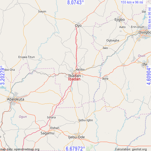
Ibadan GPS coordinates[2]
7° 22' 39.216" North, 3° 54' 21.276" East
| Map corner | latitude | longitude |
|---|---|---|
| Upper-left | 8.0743°, | 3.20279° |
| Center: | 7.37756°, | 3.90591° |
| Lower-right: | 6.67972°, | 4.60904° |
| Map W x H: | 155.1×155.1 km | = 96.4×96.4mi |
| max Lat: | 13.7543° ⇑63.8% North |
| Ibadan: | 7.37756° |
| min Lat: | ⇓36.2% South 4.31231° |
| min Long | Ibadan | max Long |
| 2.73333° | 3.90591° | 14.46552° |
| W 6.7%⇐ | ⇒93.3% E |
Elevation
Elevation of Ibadan is 181 m = 594 ft, and this is 115.5 m = 379 ft below average elevation for this country.
| Max E: |
1599 m = 5246 ft | 64.3% |
| Avg. | 296.5 m = 973 ft | |
| Ibadan | 181 m = 594 ft | |
Min E: |
2 m = 7 ft | 35.7% |
See also: Ibadan elevation on elevation.city.
Geographical zone
Ibadan is located in North Torrid zone (between Equator and Tropic of Cancer). Distance of Equator is 820.3 km =509.7 mi to South.| Distance of | km | miles | from Ibadan |
|---|---|---|---|
| North Pole | 9186.8 | 5708.4 | to North |
| Arctic Circle | 6580.9 | 4089.2 | to North |
| Tropic Cancer | 1785.6 | 1109.5 | to North |
| Equator | 820.3 | 509.7 | to South |


Nearby cities:
15 places around Ibadan: (largest is in red/bold)
• Akanran
17 km =10.6 mi,  129°
129°
• Apomu
30.7 km =19.1 mi,  95°
95°
• Egbeda
15.9 km =9.9 mi,  90°
90°
• Fiditi
37.4 km =23.2 mi,  1°
1°
• Idi-Ayunre
16.8 km =10.4 mi,  196°
196°
• Ido
19.4 km =12.1 mi,  302°
302°
• Ikire
30.9 km =19.2 mi, 91°
• Iwo
41.8 km =26 mi,  46°
46°
• Iyana-Ofa
23.5 km =14.6 mi,  55°
55°
• Jobele
42.9 km =26.7 mi, 1°
• Lalupon
20.3 km =12.6 mi, 60°
• Modakeke
39.1 km =24.3 mi, 89°
• Moniya
16.8 km =10.4 mi, 2°
• Odeda
44.7 km =27.8 mi,  248°
248°
• Olupona
39.3 km =24.4 mi, 51°
Sources, notices
• [Note1] Compared only with cities in Nigeria existing in our database
• [Src1] Map data: © OpenStreetMap contributors (CC-BY-SA)
• [Src2] Other city data from geonames.org with taken over terms of usage.
• [Src3] Geographical zone / Annual Mean Temperature by Robert A. Rohde @ Wikipedia
