Zango geodata
Zango (Katsina) is a seat of a second-order administrative division; located in Nigeria in Africa/Lagos (GMT+1) time zone. With population of 12,371 people, there are 290 cities with bigger population in this country. Compared to other cities in Nigeria, 97.5% of cities are located further ↓South; 71.4% of cities are located further ←West and 81.8% of cities have lower elevation than Zango. Note1


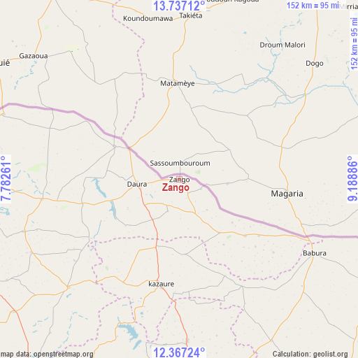
Zango GPS coordinates[2]
13° 3' 11.268" North, 8° 29' 8.664" East
| Map corner | latitude | longitude |
|---|---|---|
| Upper-left | 13.73712°, | 7.78261° |
| Center: | 13.05313°, | 8.48574° |
| Lower-right: | 12.36724°, | 9.18886° |
| Map W x H: | 152.3×152.3 km | = 94.6×94.6mi |
| max Lat: | 13.7543° ⇑2.5% North |
| Zango: | 13.05313° |
| min Lat: | ⇓97.5% South 4.31231° |
| min Long | Zango | max Long |
| 2.73333° | 8.48574° | 14.46552° |
| W 71.4%⇐ | ⇒28.6% E |
Elevation
Elevation of Zango is 484 m = 1588 ft, and this is 187.5 m = 615 ft above average elevation for this country.
| Max E: |
1599 m = 5246 ft | 18.2% |
| Zango | 484 m 1588 ft | |
| Avg. | 296.5 m = 973 ft | |
Min E: |
2 m = 7 ft | 81.8% |
See also: Nigeria elevation on elevation.city.
Geographical zone
Zango is located in North Torrid zone (between Equator and Tropic of Cancer). Distance of this Northern Tropic circle is 1154.5 km =717.4 mi to North.| Distance of | km | miles | from Zango |
|---|---|---|---|
| North Pole | 8555.7 | 5316.3 | to North |
| Arctic Circle | 5949.8 | 3697 | to North |
| Tropic Cancer | 1154.5 | 717.4 | to North |
| Equator | 1451.4 | 901.9 | to South |


Nearby cities:
15 places around Zango: (largest is in red/bold)
• Babura
65.3 km =40.6 mi,  118°
118°
• Baure
36.9 km =22.9 mi,  130°
130°
• Dambatta
68.8 km =42.8 mi,  177°
177°
• Daura
17.7 km =11 mi,  262°
262°
• Dutsi
45 km =28 mi,  236°
236°
• Gwiwa
34.2 km =21.3 mi,  208°
208°
• Ingawa
65.7 km =40.8 mi,  225°
225°
• Karkarna
32 km =19.9 mi, 175°
• Kazaure
45.7 km =28.4 mi,  190°
190°
• Kunchi
65.5 km =40.7 mi,  200°
200°
• Mai’Adua
31 km =19.3 mi,  297°
297°
• Mani
69.7 km =43.3 mi,  251°
251°
• Mashi
58.9 km =36.6 mi, 262°
• Roni
50 km =31.1 mi, 208°
• Sandamu
17 km =10.6 mi, 233°
Sources, notices
• [Note1] Compared only with cities in Nigeria existing in our database
• [Src1] Map data: © OpenStreetMap contributors (CC-BY-SA)
• [Src2] Other city data from geonames.org with taken over terms of usage.
• [Src3] Geographical zone / Annual Mean Temperature by Robert A. Rohde @ Wikipedia
