Daura geodata
Daura (Katsina) is a seat of a second-order administrative division; located in Nigeria in Africa/Lagos (GMT+1) time zone. With population of 25,289 people, there are 175 cities with bigger population in this country. Compared to other cities in Nigeria, 97.2% of cities are located further ↓South; 68.8% of cities are located further ←West and 80.9% of cities have lower elevation than Daura. Note1


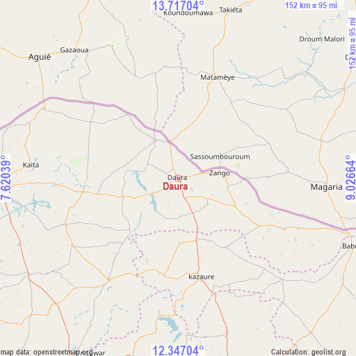
Daura GPS coordinates[2]
13° 1' 58.764" North, 8° 19' 24.636" East
| Map corner | latitude | longitude |
|---|---|---|
| Upper-left | 13.71704°, | 7.62039° |
| Center: | 13.03299°, | 8.32351° |
| Lower-right: | 12.34704°, | 9.02664° |
| Map W x H: | 152.3×152.3 km | = 94.6×94.6mi |
| max Lat: | 13.7543° ⇑2.8% North |
| Daura: | 13.03299° |
| min Lat: | ⇓97.2% South 4.31231° |
| min Long | Daura | max Long |
| 2.73333° | 8.32351° | 14.46552° |
| W 68.8%⇐ | ⇒31.2% E |
Elevation
Elevation of Daura is 475 m = 1558 ft, and this is 178.5 m = 586 ft above average elevation for this country.
| Max E: |
1599 m = 5246 ft | 19.1% |
| Daura | 475 m 1558 ft | |
| Avg. | 296.5 m = 973 ft | |
Min E: |
2 m = 7 ft | 80.9% |
See also: Nigeria elevation on elevation.city.
Geographical zone
Daura is located in North Torrid zone (between Equator and Tropic of Cancer). Distance of this Northern Tropic circle is 1156.8 km =718.8 mi to North.| Distance of | km | miles | from Daura |
|---|---|---|---|
| North Pole | 8557.9 | 5317.6 | to North |
| Arctic Circle | 5952 | 3698.4 | to North |
| Tropic Cancer | 1156.8 | 718.8 | to North |
| Equator | 1449.1 | 900.4 | to South |


Nearby cities:
15 places around Daura: (largest is in red/bold)
• Baure
50.6 km =31.4 mi,  115°
115°
• Dankama
64.4 km =40 mi,  297°
297°
• Dutsi
30.2 km =18.8 mi,  221°
221°
• Gwiwa
28 km =17.4 mi,  176°
176°
• Ingawa
52.6 km =32.7 mi,  214°
214°
• Kaita
63.4 km =39.4 mi,  275°
275°
• Karkarna
35.9 km =22.3 mi,  145°
145°
• Kazaure
43.8 km =27.2 mi,  167°
167°
• Kunchi
59.2 km =36.8 mi,  185°
185°
• Mai’Adua
19.2 km =11.9 mi,  328°
328°
• Mani
52.5 km =32.6 mi,  247°
247°
• Mashi
41.2 km =25.6 mi,  261°
261°
• Roni
42.1 km =26.2 mi, 188°
• Sandamu
8.9 km =5.5 mi, 153°
• Zango
17.7 km =11 mi,  82°
82°
Sources, notices
• [Note1] Compared only with cities in Nigeria existing in our database
• [Src1] Map data: © OpenStreetMap contributors (CC-BY-SA)
• [Src2] Other city data from geonames.org with taken over terms of usage.
• [Src3] Geographical zone / Annual Mean Temperature by Robert A. Rohde @ Wikipedia
