Araromi-Opin geodata
Araromi-Opin (Kwara) is a seat of a second-order administrative division; located in Nigeria in Africa/Lagos (GMT+1) time zone. In our database, there are 451 cities with bigger population. Compared to other cities in Nigeria, 52.4% of cities are located further ↑North; 77.7% of cities are located further →East and 86.7% of cities have lower elevation than Araromi-Opin. Note1


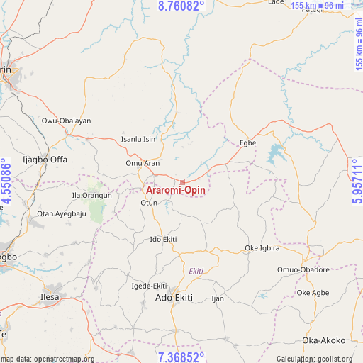
Araromi-Opin GPS coordinates[2]
8° 3' 54.972" North, 5° 15' 14.328" East
| Map corner | latitude | longitude |
|---|---|---|
| Upper-left | 8.76082°, | 4.55086° |
| Center: | 8.06527°, | 5.25398° |
| Lower-right: | 7.36852°, | 5.95711° |
| Map W x H: | 154.8×154.8 km | = 96.2×96.2mi |
| max Lat: | 13.7543° ⇑52.4% North |
| Araromi-Opin: | 8.06527° |
| min Lat: | ⇓47.6% South 4.31231° |
| min Long | Araromi-Opin | max Long |
| 2.73333° | 5.25398° | 14.46552° |
| W 22.3%⇐ | ⇒77.7% E |
Elevation
Elevation of Araromi-Opin is 521 m = 1709 ft, and this is 224.5 m = 737 ft above average elevation for this country.
| Max E: |
1599 m = 5246 ft | 13.3% |
| Araromi-Opin | 521 m 1709 ft | |
| Avg. | 296.5 m = 973 ft | |
Min E: |
2 m = 7 ft | 86.7% |
See also: Nigeria elevation on elevation.city.
Geographical zone
Araromi-Opin is located in North Torrid zone (between Equator and Tropic of Cancer). Distance of Equator is 896.8 km =557.2 mi to South.| Distance of | km | miles | from Araromi-Opin |
|---|---|---|---|
| North Pole | 9110.3 | 5660.9 | to North |
| Arctic Circle | 6504.4 | 4041.6 | to North |
| Tropic Cancer | 1709.1 | 1062 | to North |
| Equator | 896.8 | 557.2 | to South |


Nearby cities:
15 places around Araromi-Opin: (largest is in red/bold)
• Egbe
33.5 km =20.8 mi,  59°
59°
• Ido-Ekiti
25.6 km =15.9 mi,  197°
197°
• Ifaki
30.7 km =19.1 mi,  181°
181°
• Ijero-Ekiti
34.6 km =21.5 mi,  216°
216°
• Ikole-Ekiti
41.4 km =25.7 mi,  137°
137°
• Ila Orangun
38.9 km =24.2 mi,  262°
262°
• Iloffa
12.7 km =7.9 mi,  284°
284°
• Ipoti
28.9 km =18 mi, 222°
• Iye-Ekiti
12.5 km =7.8 mi,  190°
190°
• Odo-Ere
38.5 km =23.9 mi, 57°
• Oke Ila
32.4 km =20.1 mi,  246°
246°
• Omu-Aran
18.6 km =11.6 mi,  296°
296°
• Otun-Ekiti
16.8 km =10.4 mi,  239°
239°
• Owu-Isin
35.2 km =21.9 mi,  312°
312°
• Oye-Ekiti
30.8 km =19.1 mi,  163°
163°
Sources, notices
• [Note1] Compared only with cities in Nigeria existing in our database
• [Src1] Map data: © OpenStreetMap contributors (CC-BY-SA)
• [Src2] Other city data from geonames.org with taken over terms of usage.
• [Src3] Geographical zone / Annual Mean Temperature by Robert A. Rohde @ Wikipedia
