Mashi geodata
Mashi (Katsina) is a seat of a second-order administrative division; located in Nigeria in Africa/Lagos (GMT+1) time zone. With population of 7,845 people, there are 388 cities with bigger population in this country. Compared to other cities in Nigeria, 96.9% of cities are located further ↓South; 62.7% of cities are located further ←West and 84% of cities have lower elevation than Mashi. Note1


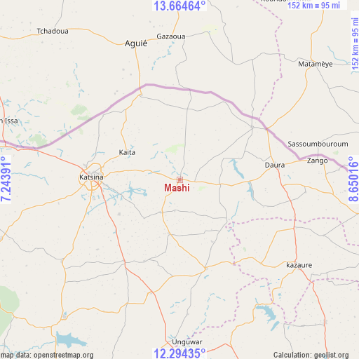
Mashi GPS coordinates[2]
12° 58' 49.584" North, 7° 56' 49.308" East
| Map corner | latitude | longitude |
|---|---|---|
| Upper-left | 13.66464°, | 7.24391° |
| Center: | 12.98044°, | 7.94703° |
| Lower-right: | 12.29435°, | 8.65016° |
| Map W x H: | 152.4×152.4 km | = 94.7×94.7mi |
| max Lat: | 13.7543° ⇑3.1% North |
| Mashi: | 12.98044° |
| min Lat: | ⇓96.9% South 4.31231° |
| min Long | Mashi | max Long |
| 2.73333° | 7.94703° | 14.46552° |
| W 62.7%⇐ | ⇒37.3% E |
Elevation
Elevation of Mashi is 494 m = 1621 ft, and this is 197.5 m = 648 ft above average elevation for this country.
| Max E: |
1599 m = 5246 ft | 16% |
| Mashi | 494 m 1621 ft | |
| Avg. | 296.5 m = 973 ft | |
Min E: |
2 m = 7 ft | 84% |
See also: Nigeria elevation on elevation.city.
Geographical zone
Mashi is located in North Torrid zone (between Equator and Tropic of Cancer). Distance of this Northern Tropic circle is 1162.6 km =722.4 mi to North.| Distance of | km | miles | from Mashi |
|---|---|---|---|
| North Pole | 8563.8 | 5321.3 | to North |
| Arctic Circle | 5957.9 | 3702.1 | to North |
| Tropic Cancer | 1162.6 | 722.4 | to North |
| Equator | 1443.3 | 896.8 | to South |


Nearby cities:
15 places around Mashi: (largest is in red/bold)
• Batagarawa
37.9 km =23.5 mi,  257°
257°
• Bindawa
37.7 km =23.4 mi,  203°
203°
• Charanchi
41.7 km =25.9 mi,  214°
214°
• Dankama
38.9 km =24.2 mi,  334°
334°
• Daura
41.2 km =25.6 mi,  81°
81°
• Dutsi
26.9 km =16.7 mi,  128°
128°
• Gwiwa
47.7 km =29.6 mi,  117°
117°
• Ingawa
39.4 km =24.5 mi,  163°
163°
• Kaita
25.1 km =15.6 mi,  297°
297°
• Katsina
37.4 km =23.2 mi,  271°
271°
• Mai’Adua
37.9 km =23.5 mi,  54°
54°
• Mani
16 km =9.9 mi, 209°
• Rimi
29.5 km =18.3 mi,  240°
240°
• Roni
49.7 km =30.9 mi,  136°
136°
• Sandamu
44.8 km =27.8 mi,  92°
92°
Sources, notices
• [Note1] Compared only with cities in Nigeria existing in our database
• [Src1] Map data: © OpenStreetMap contributors (CC-BY-SA)
• [Src2] Other city data from geonames.org with taken over terms of usage.
• [Src3] Geographical zone / Annual Mean Temperature by Robert A. Rohde @ Wikipedia
