Bindawa geodata
Bindawa (Katsina) is a seat of a second-order administrative division; located in Nigeria in Africa/Lagos (GMT+1) time zone. In our database, there are 451 cities with bigger population. Compared to other cities in Nigeria, 93% of cities are located further ↓South; 59.8% of cities are located further ←West and 87.8% of cities have lower elevation than Bindawa. Note1


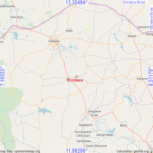
Bindawa GPS coordinates[2]
12° 40' 11.532" North, 7° 48' 31.14" East
| Map corner | latitude | longitude |
|---|---|---|
| Upper-left | 13.35494°, | 7.10553° |
| Center: | 12.66987°, | 7.80865° |
| Lower-right: | 11.98296°, | 8.51178° |
| Map W x H: | 152.5×152.6 km | = 94.8×94.8mi |
| max Lat: | 13.7543° ⇑7% North |
| Bindawa: | 12.66987° |
| min Lat: | ⇓93% South 4.31231° |
| min Long | Bindawa | max Long |
| 2.73333° | 7.80865° | 14.46552° |
| W 59.8%⇐ | ⇒40.2% E |
Elevation
Elevation of Bindawa is 532 m = 1745 ft, and this is 235.5 m = 773 ft above average elevation for this country.
| Max E: |
1599 m = 5246 ft | 12.2% |
| Bindawa | 532 m 1745 ft | |
| Avg. | 296.5 m = 973 ft | |
Min E: |
2 m = 7 ft | 87.8% |
See also: Nigeria elevation on elevation.city.
Geographical zone
Bindawa is located in North Torrid zone (between Equator and Tropic of Cancer). Distance of this Northern Tropic circle is 1197.2 km =743.9 mi to North.| Distance of | km | miles | from Bindawa |
|---|---|---|---|
| North Pole | 8598.3 | 5342.7 | to North |
| Arctic Circle | 5992.4 | 3723.5 | to North |
| Tropic Cancer | 1197.2 | 743.9 | to North |
| Equator | 1408.8 | 875.4 | to South |


Nearby cities:
15 places around Bindawa: (largest is in red/bold)
• Batagarawa
34.3 km =21.3 mi,  320°
320°
• Charanchi
8.6 km =5.3 mi,  271°
271°
• Dutsi
40 km =24.9 mi,  63°
63°
• Dutsin-Ma
41.5 km =25.8 mi,  234°
234°
• Ingawa
26.5 km =16.5 mi,  96°
96°
• Kaita
46.6 km =29 mi,  350°
350°
• Kankia
13.8 km =8.6 mi,  173°
173°
• Katsina
42.1 km =26.2 mi,  327°
327°
• Kurfi
35.1 km =21.8 mi, 269°
• Kusada
29.3 km =18.2 mi,  140°
140°
• Mani
21.7 km =13.5 mi,  19°
19°
• Mashi
37.7 km =23.4 mi, 23°
• Rimi
22.7 km =14.1 mi, 331°
• Roni
49.5 km =30.8 mi,  91°
91°
• Tsanyawa
45.9 km =28.5 mi,  155°
155°
Sources, notices
• [Note1] Compared only with cities in Nigeria existing in our database
• [Src1] Map data: © OpenStreetMap contributors (CC-BY-SA)
• [Src2] Other city data from geonames.org with taken over terms of usage.
• [Src3] Geographical zone / Annual Mean Temperature by Robert A. Rohde @ Wikipedia
