Iperindo geodata
Iperindo (Osun) is a seat of a second-order administrative division; located in Nigeria in Africa/Lagos (GMT+1) time zone. In our database, there are 451 cities with bigger population. Compared to other cities in Nigeria, 61.5% of cities are located further ↑North; 83.5% of cities are located further →East and 53.9% of cities have lower elevation than Iperindo. Note1


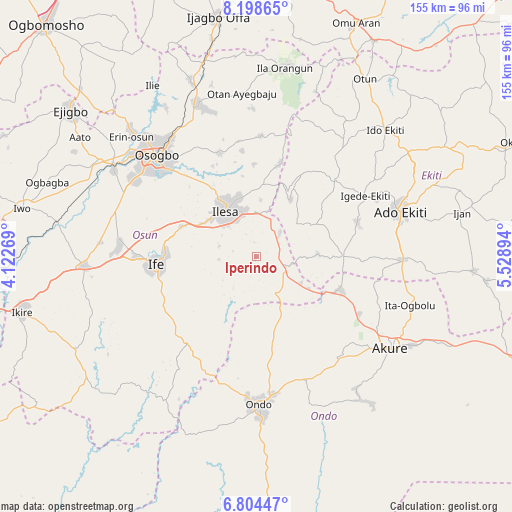
Iperindo GPS coordinates[2]
7° 30' 7.632" North, 4° 49' 32.952" East
| Map corner | latitude | longitude |
|---|---|---|
| Upper-left | 8.19865°, | 4.12269° |
| Center: | 7.50212°, | 4.82582° |
| Lower-right: | 6.80447°, | 5.52894° |
| Map W x H: | 155×155 km | = 96.3×96.3mi |
| max Lat: | 13.7543° ⇑61.5% North |
| Iperindo: | 7.50212° |
| min Lat: | ⇓38.5% South 4.31231° |
| min Long | Iperindo | max Long |
| 2.73333° | 4.82582° | 14.46552° |
| W 16.5%⇐ | ⇒83.5% E |
Elevation
Elevation of Iperindo is 303 m = 994 ft, and this is 6.5 m = 21 ft above average elevation for this country.
| Max E: |
1599 m = 5246 ft | 46.1% |
| Iperindo | 303 m 994 ft | |
| Avg. | 296.5 m = 973 ft | |
Min E: |
2 m = 7 ft | 53.9% |
See also: Nigeria elevation on elevation.city.
Geographical zone
Iperindo is located in North Torrid zone (between Equator and Tropic of Cancer). Distance of Equator is 834.2 km =518.3 mi to South.| Distance of | km | miles | from Iperindo |
|---|---|---|---|
| North Pole | 9172.9 | 5699.8 | to North |
| Arctic Circle | 6567 | 4080.5 | to North |
| Tropic Cancer | 1771.8 | 1100.9 | to North |
| Equator | 834.2 | 518.3 | to South |


Nearby cities:
15 places around Iperindo: (largest is in red/bold)
• Aramoko-Ekiti
32.7 km =20.3 mi,  46°
46°
• Efon-Alaaye
20.2 km =12.6 mi,  31°
31°
• Ibokun
33.4 km =20.8 mi,  341°
341°
• Ifetedo
38 km =23.6 mi,  201°
201°
• Igbara-Odo
26.1 km =16.2 mi,  89°
89°
• Igbara-Oke
27.5 km =17.1 mi,  111°
111°
• Igede-Ekiti
37.9 km =23.5 mi,  60°
60°
• Ijebu-Jesa
20.1 km =12.5 mi,  357°
357°
• Ilare
35.9 km =22.3 mi,  117°
117°
• Ilawe-Ekiti
32.6 km =20.3 mi,  70°
70°
• Ile-Ife
29.4 km =18.3 mi,  265°
265°
• Ile-Oluji
32.5 km =20.2 mi,  171°
171°
• Ilesa
16.8 km =10.4 mi,  326°
326°
• Oke Mesi
36.4 km =22.6 mi,  15°
15°
• Osu
24.2 km =15 mi,  292°
292°
Sources, notices
• [Note1] Compared only with cities in Nigeria existing in our database
• [Src1] Map data: © OpenStreetMap contributors (CC-BY-SA)
• [Src2] Other city data from geonames.org with taken over terms of usage.
• [Src3] Geographical zone / Annual Mean Temperature by Robert A. Rohde @ Wikipedia
