Ehor geodata
Ehor (Edo) is a seat of a second-order administrative division; located in Nigeria in Africa/Lagos (GMT+1) time zone. In our database, there are 451 cities with bigger population. Compared to other cities in Nigeria, 74.1% of cities are located further ↑North; 70.7% of cities are located further →East and 55.4% of cities have higher elevation than Ehor. Note1


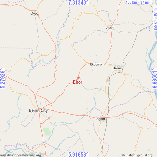
Ehor GPS coordinates[2]
6° 36' 55.8" North, 5° 58' 56.568" East
| Map corner | latitude | longitude |
|---|---|---|
| Upper-left | 7.31343°, | 5.27926° |
| Center: | 6.6155°, | 5.98238° |
| Lower-right: | 5.91658°, | 6.68551° |
| Map W x H: | 155.3×155.3 km | = 96.5×96.5mi |
| max Lat: | 13.7543° ⇑74.1% North |
| Ehor: | 6.6155° |
| min Lat: | ⇓25.9% South 4.31231° |
| min Long | Ehor | max Long |
| 2.73333° | 5.98238° | 14.46552° |
| W 29.3%⇐ | ⇒70.7% E |
Elevation
Elevation of Ehor is 245 m = 804 ft, and this is 51.5 m = 169 ft below average elevation for this country.
| Max E: |
1599 m = 5246 ft | 55.4% |
| Avg. | 296.5 m = 973 ft | |
| Ehor | 245 m = 804 ft | |
Min E: |
2 m = 7 ft | 44.6% |
See also: Nigeria elevation on elevation.city.
Geographical zone
Ehor is located in North Torrid zone (between Equator and Tropic of Cancer). Distance of Equator is 735.6 km =457.1 mi to South.| Distance of | km | miles | from Ehor |
|---|---|---|---|
| North Pole | 9271.5 | 5761 | to North |
| Arctic Circle | 6665.6 | 4141.8 | to North |
| Tropic Cancer | 1870.3 | 1162.2 | to North |
| Equator | 735.6 | 457.1 | to South |


Nearby cities:
15 places around Ehor: (largest is in red/bold)
• Abudu
36 km =22.4 mi,  171°
171°
• Afuze
39.9 km =24.8 mi,  9°
9°
• Agbor
46.5 km =28.9 mi,  149°
149°
• Benin City
50 km =31.1 mi,  231°
231°
• Ekpoma
22.5 km =14 mi,  50°
50°
• Idogbo
48.8 km =30.3 mi,  217°
217°
• Ifon
41.9 km =26 mi,  326°
326°
• Igueben
28.8 km =17.9 mi,  93°
93°
• Irrua
29.5 km =18.3 mi,  62°
62°
• Owa-Oyibu
53.8 km =33.4 mi, 153°
• Sabongida-Ora
32.4 km =20.1 mi,  349°
349°
• Ubiaja
44.7 km =27.8 mi,  84°
84°
• Umunede
53.1 km =33 mi,  137°
137°
• Uromi
39.9 km =24.8 mi, 76°
• Uselu
48.5 km =30.1 mi,  238°
238°
Sources, notices
• [Note1] Compared only with cities in Nigeria existing in our database
• [Src1] Map data: © OpenStreetMap contributors (CC-BY-SA)
• [Src2] Other city data from geonames.org with taken over terms of usage.
• [Src3] Geographical zone / Annual Mean Temperature by Robert A. Rohde @ Wikipedia
