Gummi geodata
Gummi (Zamfara) is a seat of a second-order administrative division; located in Nigeria in Africa/Lagos (GMT+1) time zone. With population of 38,744 people, there are 154 cities with bigger population in this country. Compared to other cities in Nigeria, 86.2% of cities are located further ↓South; 79.8% of cities are located further →East and 57% of cities have higher elevation than Gummi. Note1


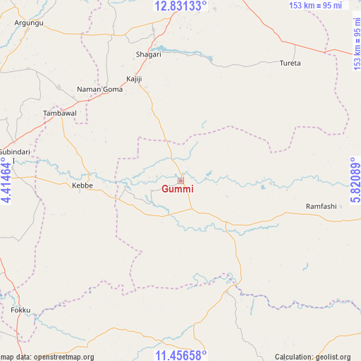
Gummi GPS coordinates[2]
12° 8' 41.424" North, 5° 7' 3.936" East
| Map corner | latitude | longitude |
|---|---|---|
| Upper-left | 12.83133°, | 4.41464° |
| Center: | 12.14484°, | 5.11776° |
| Lower-right: | 11.45658°, | 5.82089° |
| Map W x H: | 152.9×152.9 km | = 95×95mi |
| max Lat: | 13.7543° ⇑13.8% North |
| Gummi: | 12.14484° |
| min Lat: | ⇓86.2% South 4.31231° |
| min Long | Gummi | max Long |
| 2.73333° | 5.11776° | 14.46552° |
| W 20.2%⇐ | ⇒79.8% E |
Elevation
Elevation of Gummi is 233 m = 764 ft, and this is 63.5 m = 208 ft below average elevation for this country.
| Max E: |
1599 m = 5246 ft | 57% |
| Avg. | 296.5 m = 973 ft | |
| Gummi | 233 m = 764 ft | |
Min E: |
2 m = 7 ft | 43% |
See also: Nigeria elevation on elevation.city.
Geographical zone
Gummi is located in North Torrid zone (between Equator and Tropic of Cancer). Distance of this Northern Tropic circle is 1255.5 km =780.1 mi to North.| Distance of | km | miles | from Gummi |
|---|---|---|---|
| North Pole | 8656.7 | 5379 | to North |
| Arctic Circle | 6050.8 | 3759.8 | to North |
| Tropic Cancer | 1255.5 | 780.1 | to North |
| Equator | 1350.4 | 839.1 | to South |


Nearby cities:
15 places around Gummi: (largest is in red/bold)
• Aliero
72 km =44.7 mi,  282°
282°
• Bodinga
77.8 km =48.3 mi,  2°
2°
• Bukkuyum
38.1 km =23.7 mi,  91°
91°
• Dabai
74.9 km =46.5 mi,  172°
172°
• Dange
82.6 km =51.3 mi,  17°
17°
• Gwandu
65.1 km =40.5 mi,  307°
307°
• Jega
80.7 km =50.1 mi, 276°
• Kebbe
41.7 km =25.9 mi,  267°
267°
• Mahuta
67.4 km =41.9 mi,  192°
192°
• Maiyama
81.7 km =50.8 mi, 265°
• Shagari
55.3 km =34.4 mi,  345°
345°
• Tambuwal
58.9 km =36.6 mi,  299°
299°
• Tureta
68.1 km =42.3 mi,  42°
42°
• Yabo
65.2 km =40.5 mi, 349°
• Zuru
79.9 km =49.6 mi, 170°
Sources, notices
• [Note1] Compared only with cities in Nigeria existing in our database
• [Src1] Map data: © OpenStreetMap contributors (CC-BY-SA)
• [Src2] Other city data from geonames.org with taken over terms of usage.
• [Src3] Geographical zone / Annual Mean Temperature by Robert A. Rohde @ Wikipedia
