Gwandu geodata
Gwandu (Kebbi) is a seat of a second-order administrative division; located in Nigeria in Africa/Lagos (GMT+1) time zone. With population of 10,018 people, there are 332 cities with bigger population in this country. Compared to other cities in Nigeria, 90.8% of cities are located further ↓South; 86.2% of cities are located further →East and 54.7% of cities have higher elevation than Gwandu. Note1


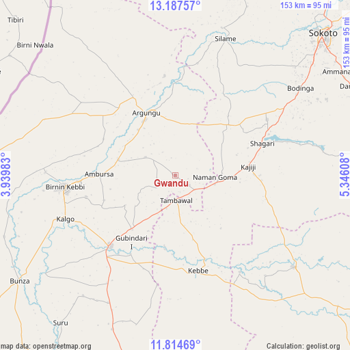
Gwandu GPS coordinates[2]
12° 30' 7.344" North, 4° 38' 34.62" East
| Map corner | latitude | longitude |
|---|---|---|
| Upper-left | 13.18757°, | 3.93983° |
| Center: | 12.50204°, | 4.64295° |
| Lower-right: | 11.81469°, | 5.34608° |
| Map W x H: | 152.6×152.7 km | = 94.8×94.9mi |
| max Lat: | 13.7543° ⇑9.2% North |
| Gwandu: | 12.50204° |
| min Lat: | ⇓90.8% South 4.31231° |
| min Long | Gwandu | max Long |
| 2.73333° | 4.64295° | 14.46552° |
| W 13.8%⇐ | ⇒86.2% E |
Elevation
Elevation of Gwandu is 249 m = 817 ft, and this is 47.5 m = 156 ft below average elevation for this country.
| Max E: |
1599 m = 5246 ft | 54.7% |
| Avg. | 296.5 m = 973 ft | |
| Gwandu | 249 m = 817 ft | |
Min E: |
2 m = 7 ft | 45.3% |
See also: Nigeria elevation on elevation.city.
Geographical zone
Gwandu is located in North Torrid zone (between Equator and Tropic of Cancer). Distance of this Northern Tropic circle is 1215.8 km =755.5 mi to North.| Distance of | km | miles | from Gwandu |
|---|---|---|---|
| North Pole | 8617 | 5354.4 | to North |
| Arctic Circle | 6011.1 | 3735.1 | to North |
| Tropic Cancer | 1215.8 | 755.5 | to North |
| Equator | 1390.1 | 863.8 | to South |


Nearby cities:
15 places around Gwandu: (largest is in red/bold)
• Aliero
30.2 km =18.8 mi,  218°
218°
• Argungu
29.9 km =18.6 mi,  334°
334°
• Augie
43.4 km =27 mi,  353°
353°
• Birnin Kebbi
48.7 km =30.3 mi,  263°
263°
• Bodinga
66.9 km =41.6 mi,  55°
55°
• Gulma
34.9 km =21.7 mi,  296°
296°
• Gummi
65.1 km =40.5 mi,  127°
127°
• Jega
42.2 km =26.2 mi, 222°
• Kalgo
51.9 km =32.2 mi,  247°
247°
• Kebbe
42.7 km =26.5 mi,  166°
166°
• Maiyama
55.4 km =34.4 mi,  212°
212°
• Shagari
40.5 km =25.2 mi,  69°
69°
• Silame
63.7 km =39.6 mi,  20°
20°
• Tambuwal
10.7 km =6.6 mi,  178°
178°
• Yabo
47.1 km =29.3 mi, 58°
Sources, notices
• [Note1] Compared only with cities in Nigeria existing in our database
• [Src1] Map data: © OpenStreetMap contributors (CC-BY-SA)
• [Src2] Other city data from geonames.org with taken over terms of usage.
• [Src3] Geographical zone / Annual Mean Temperature by Robert A. Rohde @ Wikipedia
